Big Basin State Park: Waddell Beach to Berry Creek Falls & Beyond!

On September 7th I did a big hike of 20 miles with a few friends. Due to the warmer weather, we decided to head towards the coast and redwoods. Michael suggested starting at Waddell Beach in Big Basin State Park. Great idea!

IMG_1473

IMG_1476

Big Basin State Park was California’s first state park and one of the most popular. The campgrounds book-up very far in advance in the summer with families and tourists. There ARE several other entrances to the park for us “locals” who avoid the crowds and Visitor’s Center.

Park information: http://www.parks.ca.gov/?page_id=540

Park brochure and map: http://www.parks.ca.gov/pages/540/files/BigBasinRedwoodsFinalWebLayout030311.pdf

From the scenic beach, with quite a few kite surfers, up we went!

IMG_1480

After awhile we’d left the beach behind and enjoyed the cool, calm redwood forest.

IMG_1494

The park has many trails, which are well-marked, though you do need a map of some sort!

IMG_1496

Interestingly, we spotted this piece of old equipment. It was likely used to move logs out of the forest at some point. We noticed the large balloon tires, as well as the un-rusted wheels.

IMG_1529

Upon closer examination we found the wheels were aluminum and had serial numbers, as well as a date of manufacture from 1942. Re-purposed aircraft wheels! …which were likely available right after the war at scrap metal prices.

IMG_1492

It was wonderful to see and hear flowing water as we went uphill, given the extreme drought we’ve had recently.

IMG_1499

Soon, we approached Berry Creek Falls, which, besides the large redwoods, is the most popular attraction in the park.

IMG_1500

Most visitors to the falls walk downhill from the Park HQ, versus our uphill direction from the beach.

IMG_1505

IMG_1504

Above Berry Creek Falls, the waterflow is quite close to the trail. I suspect this may be closed and/or dangerous after a rain.

IMG_1511

Sunset Camp is one of several “Backpack Camps” in the park. They take a little effort to get to, including packing your own water, but can be quite peaceful!

IMG_1513

Continuing higher, we eventually lost all traces of water and redwoods. Like the neighboring “Chalk Mountain”, the soil is dry and less fertile than lower parts of the park. It appears to be ancient beach sand.

IMG_1516

Chalk Mountain in the distance!

IMG_1519

Getting ready to head down. Time for the redwoods again!

IMG_1520

Let your eyes follow the valley, from close-in to the far horizon, just to the right of center. This was our route to/from the beach, which is just out of sight in the distance, about 8 miles as the crow flies.

IMG_1524

There’s the beach! Almost back!

IMG_1532

Details!

The park brochure and map are linked above. The beach entrance is on the coast about 20 minutes north of Santa Cruz (no cell reception!)

Here’s a link to the Strava track: http://www.strava.com/activities/191481024

Posted in Uncategorized | Leave a comment

Kayaking Independence Lake – Nature Conservancy’s pristine spot (Tahoe Truckee)

IMG_0830

The Lake Tahoe region is known as a “wonderland” for year-round recreation. It’s also known for it’s crowds! Just 22 miles north-west of Truckee lies one of the most pristine lakes in the West. It’s about the same size as Donner Lake, if you’re familiar with that (~3 miles long) http://www.nature.org/ourinitiatives/regions/northamerica/unitedstates/nevada/placesweprotect/independence-lake.xml

The Nature Conservancy purchased this entire lake from a private owner a few years ago and it’s open to the public…with some precautions to keep it pristine!

Because the former private owners ensured limited access, Independence Lake does not have any invasive species and is only one of 2 places that has a natural (unstocked / naturally replenishing) population of Lahontan Cutthroat Trout. (Fishing is allowed with some restrictions. The Lahontan Cutthroat Trout is “threatened” under the Endangered Species Act and must be released. http://www.nature.org/ourinitiatives/regions/northamerica/unitedstates/nevada/independence-lake-fishing-information.pdf)

Damaging invasive species, such as snails, mussels, and plants, often hitch rides on watercraft. Because of this, no outside watercraft are allowed. HOWEVER, the Nature Conservancy generously provides a handful of kayaks on a first-come, first-serve basis to the public (and motorboats on alternate weeks). There is no charge for these watercraft, but I would encourage putting a donation in the little box on the sign board. (A rented kayak elsewhere, without this pristine scenery, would cost about $30.)

The posted hours are 7:00AM – 7:00PM in the summer season. I visited on 2 weekdays in late July. One day there was an ample supply of kayaks (I was the only one on the water until about 10:00AM). The other day had a flurry of activity from an educational group and all the kayaks were taken well before 10:00AM.

If you’re a landlubber, or get there late, you may enjoy a hike along the shore. The northern shore is a truck road and the southern shore is a bit rougher, from the bit that I saw. I don’t think they connect at the far end.

IMG_0833

Park at the designated area, and walk towards the caretaker’s cabin and sign in!

IMG_0821

IMG_0823

At one time there was a hotel and cabins here. One old building remains, besides the new caretaker’s cabin:

IMG_0825

Walk down to the shore, a few hundred yards, and off you go! (FYI: There’s nobody to help you with the equipment, teach you to kayak, or to rescue you if you get in trouble! Wear the lifejacket and know what you’re doing. Watch for thunderstorms as well.)

IMG_0852

In the early morning the water was incredibly still! The breeze typically picks-up later in the morning, giving you a small tailwind for your return…or a headwind on your outbound direction if you sleep-in and start late)

IMG_0844

IMG_0828

I kayaked the full length of the lake (approx 2.5 or 3 miles). While resting at the far end, along the left shore, I was “buzzed” twice by a bald eagle. Unfortunately my camera was stowed-away in a dry bag at the time. It wasn’t the first time I’ve seen one, but definitely the best!

IMG_0863

Around 10:30AM I started seeing “classic Sierra thunderheads” rolling towards me from behind the peaks to the right. I made my return to the launching point, and started walking towards the car and BOOM! …at 11:15 I heard the first nearby crack of thunder. What a great experience!

——–

GETTING THERE

These directions are excellent (bottom of this page): http://www.nature.org/ourinitiatives/regions/northamerica/unitedstates/nevada/placesweprotect/independence-lake.xml Write them down, or take a screen shot, as your phone will be “off the grid” after you leave Truckee!

The Nature Conservancy recommends a high clearance vehicle, which I agree with. I drove the road when it was dry and had no problems in my normal 2WD sedan. Take it slow and watch for protruding rocks, where you should be experienced at putting your wheels on the high spots, not in the low spots.

Getting to Independence Lake from Interstate-80/Truckee, CA:

•Exit I-80 to Route 89 North – Sierraville.
•Travel approximately 15 miles North on Highway 89 to Independence Lake/Webber Lake/Jackson Meadow Reservoir turn-off.
•Turn Left/West off of Route 89 toward Independence Lake/Webber Lake/Jackson Meadow Reservoir.
•Bear left and stay on paved road for 1.5 miles. Turn Left/South at sign for “Independence Lake – 5 miles.”
•Continue approximately 5 miles to Independence Lake. The road becomes a rough dirt road. High clearance vehicle advised. After roughly 2 miles you reach a fork in the road and a sign for “Independence Lake – 3 miles.” Take the RIGHT fork of the road. After approx. ½ mile there is another fork, follow the LEFT fork across a stream. If you do not drive across a stream soon after taking this left fork, you have made a wrong turn. Continue along this road going roughly south.
•Follow the directional signs to the parking area.

Looking back after turning west off of Highway 89:

IMG_0811

OK spelling geeks, how many times does the letter “A” appear in the name of this lake?

IMG_0815

This is the creek crossing mentioned above. It’s easy if it hasn’t been raining recently. Just about 2 inches deep with some solid coarse gravel.

IMG_0817

Typical section of the 5 miles to get there from Highway 89. Some sections are steeper and rockier than this:

IMG_0819

That’s it! GET THERE EARLY if you want a kayak of your choice (and also to avoid possible afternoon lightning!)

Posted in Uncategorized | 2 Comments

“Secret” Entrance to Pescadero Creek Park from Big Basin

Pescadero2

Wouldn’t it be interesting to learn of a “back door” to Pescadero Creek County Park (and upper Big Basin State Park)? No crowds, no entrance fees, and great views of the Pacific Ocean if the weather is cooperating!

IMG_0282

In the upper reaches of Big Basin State Park:

IMG_0241

About 4 miles north of the park HQ, you’ll find a westbound turn on to China Grade Road. This is the upper boundary of the park and is quite sunny and dry compared to lower elevations.

IMG_0240

Drive a few miles to approximately N 37° 12.900 W 122° 13.290 and look for a gated logging road and a small trail sign on your right at a pullout. (The coords are within about 100 feet of being accurate.) The logging road is not open to the public, but there’s a foot trail next to it that’s an “easement” for hikers and equestrians. It’s a bit over a mile, on the easement, from there to the boundary of Pescadero Creek County Park.

IMG_0247

Be sure you have some sort of navigation skills and mapping tools. The first time I was here with a few friends, we ended-up missing where the trail crosses a logging road and went down the road for awhile…

Here’s the official map. The easement enters the main map at the extreme botton corner “Basin Trail Easement” https://parks.smcgov.org/sites/parks.smcgov.org/files/Pescadero-SamMcDonald-Memorial-Complex-Map.pdf …and the park brochure: https://parks.smcgov.org/sites/parks.smcgov.org/files/Pescadero-Complex-Brochure.pdf

Eventually you’ll “hang a left” and see some sandstone formations.

IMG_0251

This one looks like a face. My water bottle was placed there for scale. (One friend asked what was the colored stuff in the bottom of the bottle! It’s a Nuun Electrolyte tablet. It is not a lab sample…

IMG_0276

…and more typical views of the trail:

IMG_0256

If you choose to continue to the north-west like I did, along the park’s boundary, you’ll eventually see a crossroads down to the main (lower) part of the park. If you REALLY want to “get remote” and do another few miles of even steeper dips…

IMG_0259

You should (weather permitting!) be rewarded with some magnificent ocean views!

IMG_0261

IMG_0262

IMG_0266

It’s a hilly roundtrip hike of 15+ miles:

IMG_0269

You may even spot this odd stump with 3 significant “children” growing out of it:

IMG_0280

That’s it! Enjoy your “no crowds, no entrance fees, and no drinking water” hike from Big Basin to Pescadero Creek Park.

Also consider a bit further down the road you parked on is Big Basin’s “Johansen Road” trail, as well as an even more obscure easement into Butano State Park. http://www.parks.ca.gov/pages/540/files/BigBasinRedwoodsFinalWebLayout030311.pdf

and http://www.everytrail.com/view_trip.php?trip_id=2061281

There are also 2 other awesome hikes not “too” far from here. You’ll have to surf a bit (or drop me a note) to find those entrances. “Beverly Hillbillies crude oil” https://alpharoaming.com/2013/08/31/up-from-the-ground/ and Peter’s Creek remote old growth redwoods! https://alpharoaming.com/2013/09/16/peters-creek-old-growth-redwoods-portola-redwoods-state-park/

Posted in Uncategorized | 2 Comments

The Wild Parrots of Sunnyvale!…and Telegraph Hill!

Many folks have heard of the movie “The Wild Parrots of Telegraph Hill”, released in 2003 http://en.wikipedia.org/wiki/The_Wild_Parrots_of_Telegraph_Hill Have you heard of The Wild Parrots of Sunnyale?

About 10 years ago they first caught my attention while I was in the parking lot of Toys-R-Us. I heard an unusual and happy cluster of “squawks” and looked up to see about 8 green birds flying overhead.

At that time there was one or two minor references on the internet, including one YouTube video. Now there are many more references, websites, pictures, and even their own Twitter account @SvlWildParrots

Rick Rutna has a great writeup from 2012, which is MUCH better than anything else. If you only read one link, read this one: http://ricktrutna.com/?p=13

Earlier material on the birds:

San Jose Metro from 1998: http://www.metroactive.com/papers/metro/08.20.98/slices-9833.html

YouTube 2009: http://www.youtube.com/watch?v=AEctNrEQhFM
…and YouTube 2010: http://www.youtube.com/watch?v=5qrUa7Wp2x8
…and about 10 more videos if you search “Sunnyvale” and “Parrots”

A small article from 2009: http://www.examiner.com/article/stress-eased-by-connecting-with-the-wild-parrots-of-sunnyvale

More recent, and very nice close-ups, here: http://photography-on-the.net/forum/showthread.php?t=482174

..and here: https://www.flickr.com/photos/larryhendler/2391148829/

A Geocache, for those of you who know what that is… http://www.geocaching.com/geocache/GC1V23Z_wild-parrots-of-sunnyvale

Living not too far away, I have become accustomed to looking up when I hear their sounds several times a week. They apparently travel during the day and end-up back in or near Las Palmas Park for the evening. As for me, I enjoy their sounds and can’t imagine what it would be like to live in a cage instead!

There you go! A quick summary of the better links regarding this “almost famous” flock!

Posted in Uncategorized | 1 Comment

Historic Alviso, CA (a photo essay in San Jose!)

Foreword and update to the below blog post:

A few weeks after my original publication of the below blog post, it was noticed by some members of the Alviso community and became my most widely read post as of yet. (second place is the one about Neil Young’s ranch in the hills above Woodside).

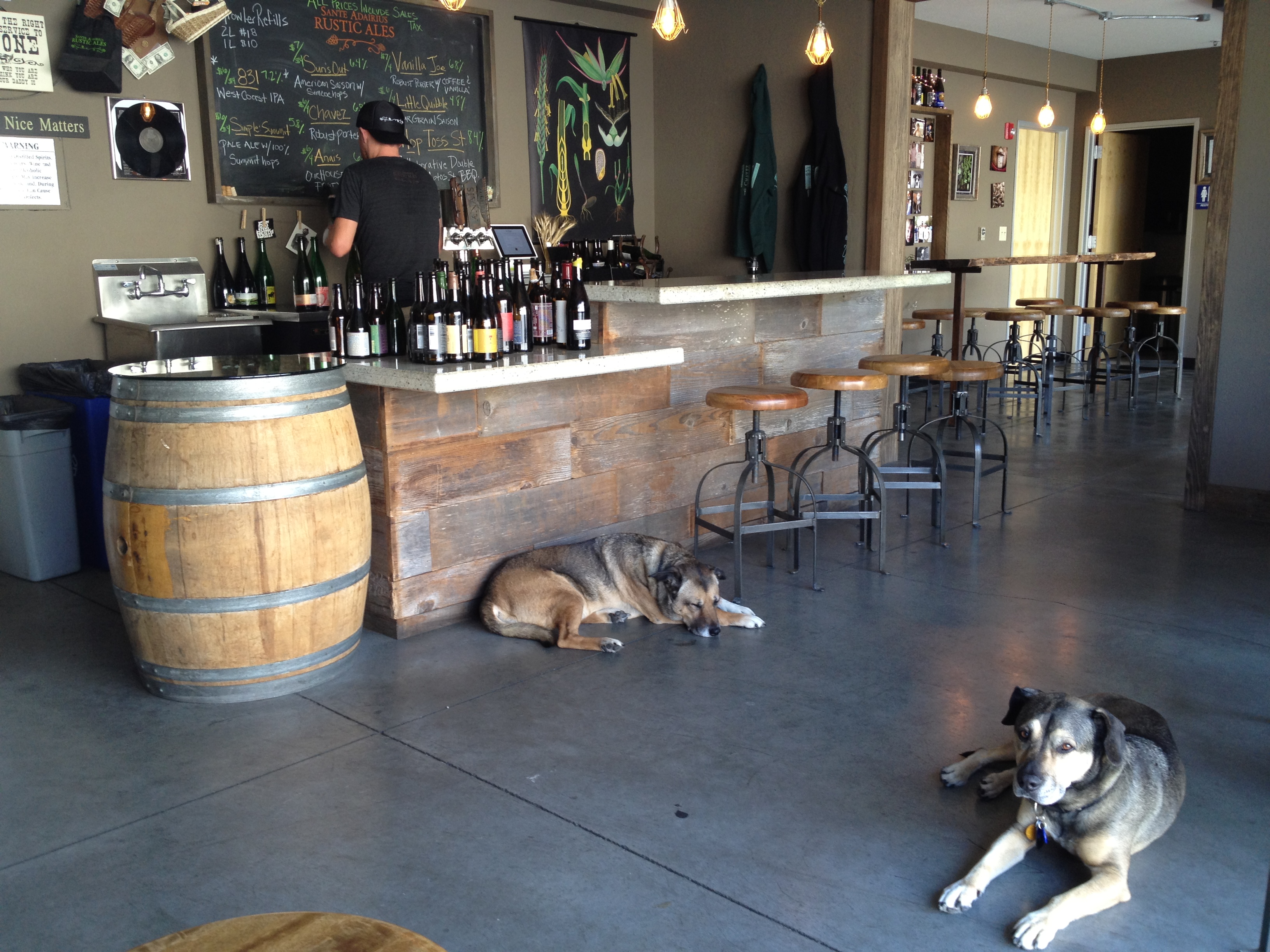
I was invited to have a look inside the “mysterious” South Bay Yacht Club. Indeed it is active and well! On August 30th there was an “Open House” and an art exhibit by Emmett Dingle. Also, the bar was open and staffed by Diane, who also manages rentals of the SBYC for family and small corporate gatherings.

IMG_1373

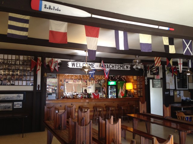
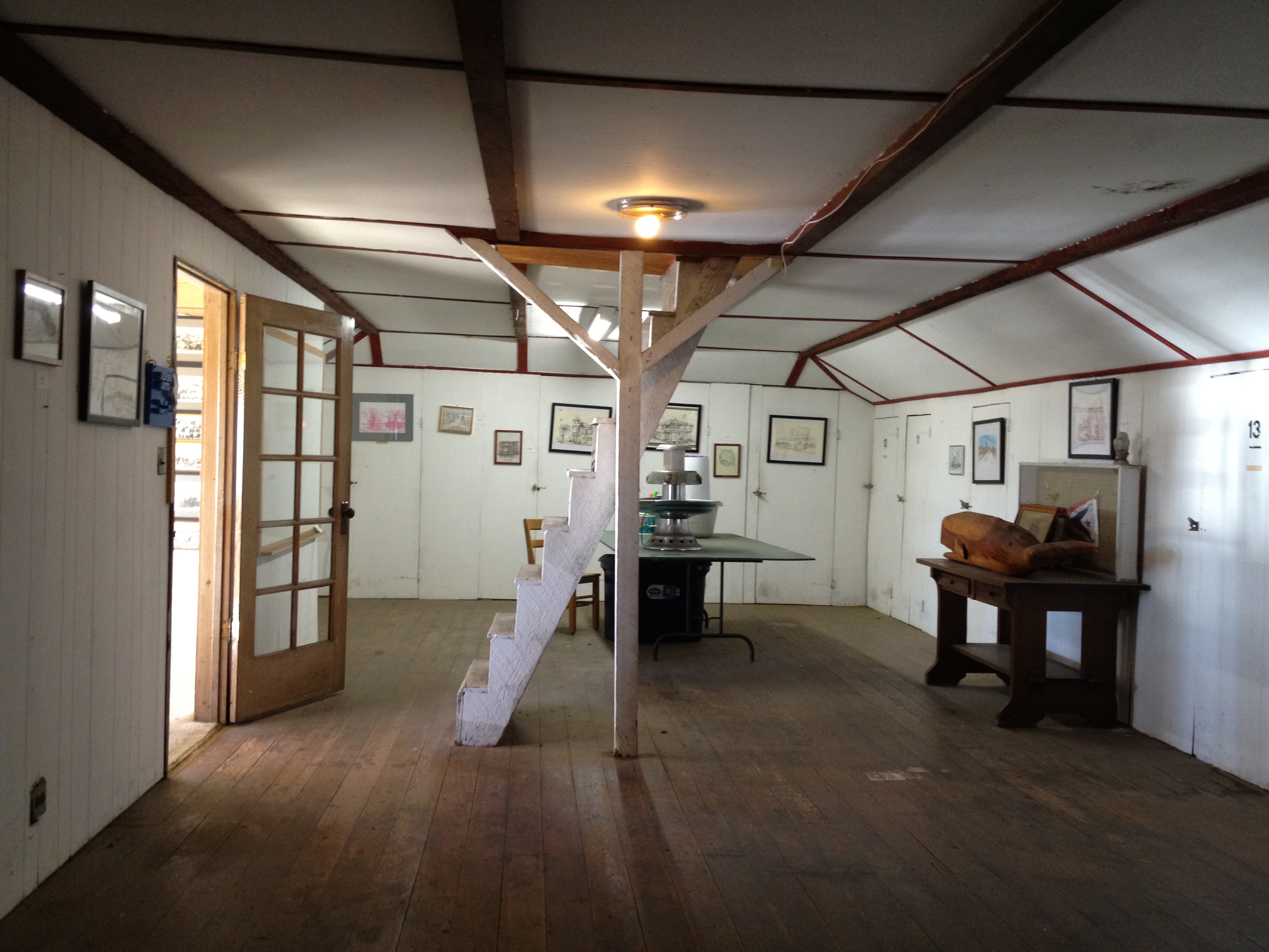
The first floor has displays on the wall of the club’s history. The second floor (pictured below) has additional history displays, plus the art of Emmett Dingle.

IMG_1377

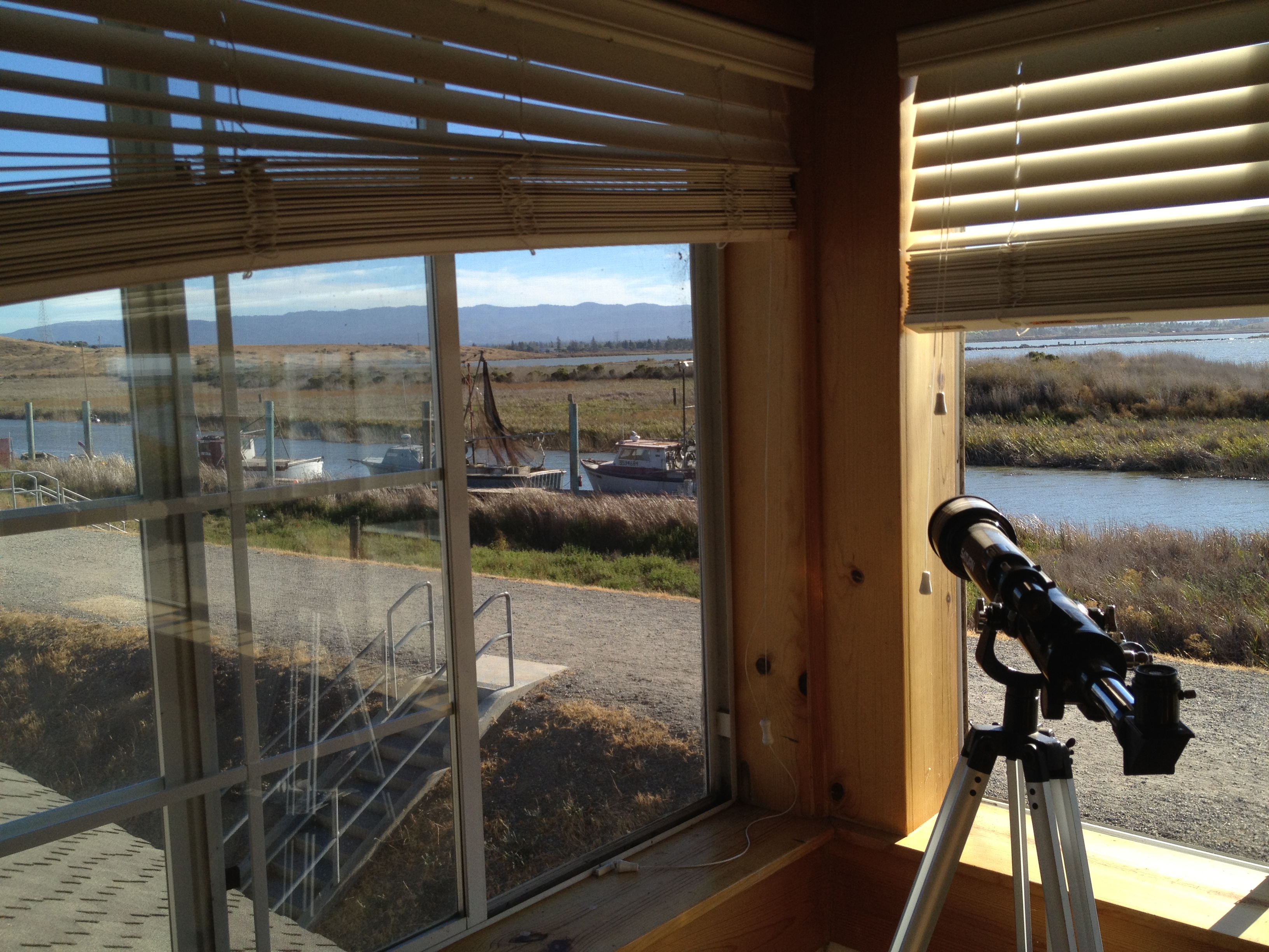
The view out the front of the second floor, about 2 hours before sunset was magnificent! I can imagine sitting up here with a rocking chair and a drink, either during a sunset or a rare rainstorm.

IMG_1382

IMG_1386

If you’d like to see the inside of the building too, I encourage you to watch their website for public events. http://www.southbayyachtclub.org/ Also, consider renting their facility for your next event! http://www.southbayyachtclub.org/about.php

Many thanks to the club’s Commodore, Charles Taylor, as well as Diane, who was fascinating to talk to while she took good care of the bar. Additional thanks to Charles’s wife who was kind enough to pass around my blog post and suggest that I visit!

The following is the original post:

Since moving to the San Francisco Bay Area in 1990, I have had an odd fascination with Alviso. Alviso is a neighborhood (town) at the southern edge of the bay that seems “frozen in time” …and I mean that in a good way!

I’ve always had a bit of a “history bug”, having grown-up near forts, battlefields, and skirmishes surrounding the American Revolution, as well as the French and Indian War prior to that. What else could capture a young boy’s imagination more than visiting a monument to Benedict Arnold’s leg, http://en.wikipedia.org/wiki/Boot_Monument, and vacationing on the beach near “Bloody Pond” where several hundred colonists were slaughtered? http://www.historiclakes.org/wm_henry/bloody.html

Anyway…one of the first fascinating historical sites that I fixed my interest on, after moving to Silicon Valley 20+ years ago was Alviso, California. That interest came about one day reading the San Jose Metro newspaper. Eric Carlson had a great series called “SJ Underbelly”. Alviso was his most extensively covered location. http://www.sanjose.com/underbelly/unbelly/Alviso/alviso1.html

Eric Carlson’s old write-ups have been preserved, but Alviso has changed…just a little! Some of the messier storage yards and junked cars have been cleared and some bronze historical markers have been added. It still has all that “frozen in time” charm, however, that generally doesn’t exist elsewhere in Silicon Valley.

“Why Alviso?” Well, it was a historical port for goods and people to travel to and from San Francisco, before ground transportation up and down the Peninsula was easy. Alviso seems to have a sense of (underappreciated) history amidst all of the tear-it-down-and-rebuild-it of Silicon Valley. https://alpharoaming.com/2014/05/05/apple-spaceship/

My plan with this blog post is to both point out the interesting place that is Alviso, as well as draw attention to Eric Carlsen’s fine work and update it with a few photos of my own. Enjoy!

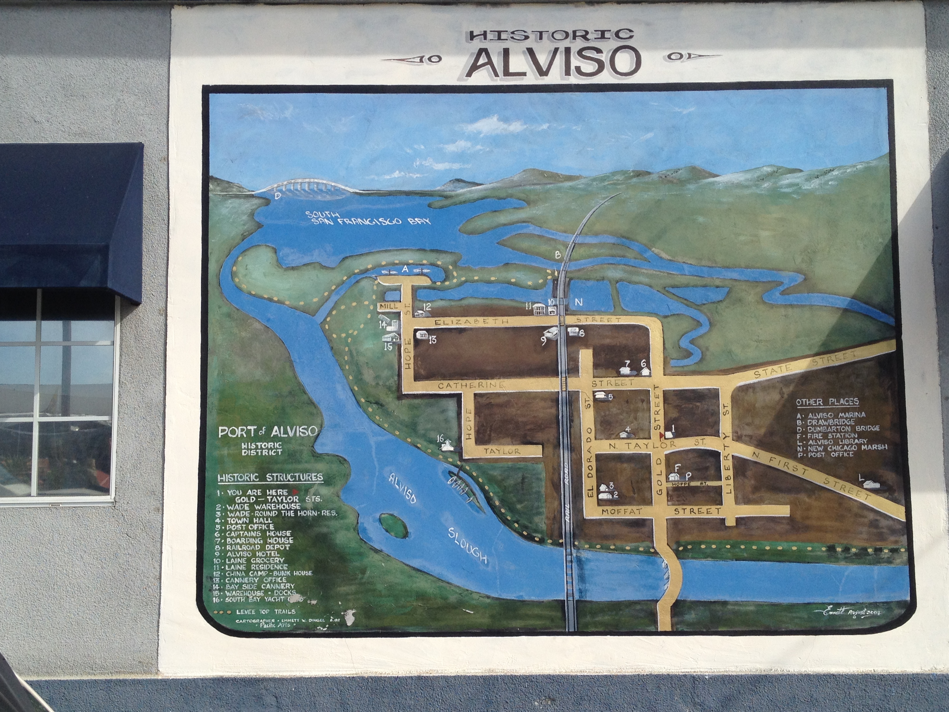
A mural at the main crossroads in town by Emmett Dingle:

IMG_8881

Let’s start our tour out near the former port, at the far end of town, and work our way back south.

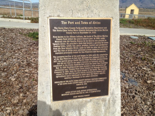
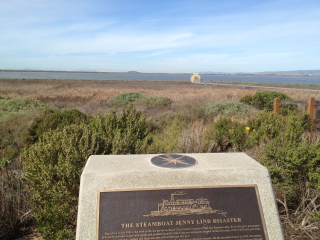
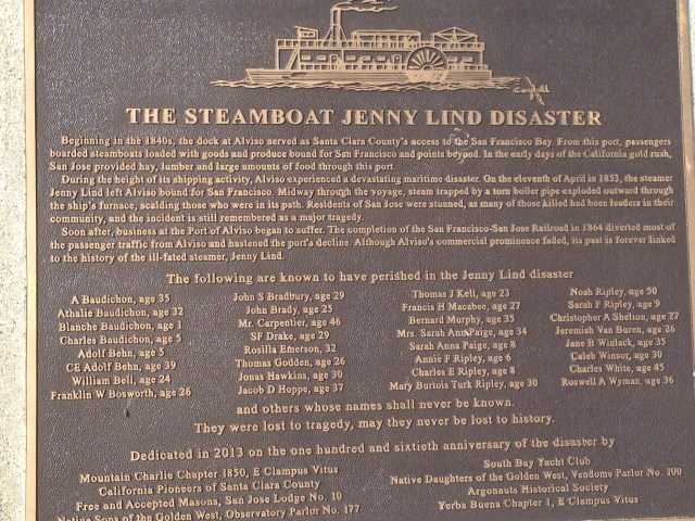
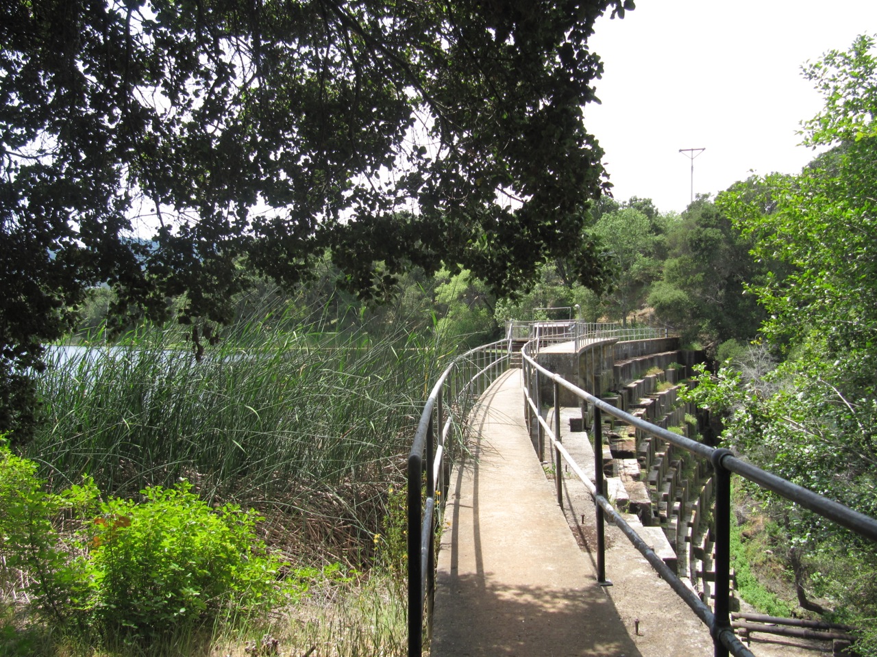
This bronze marker is just a few years old. Note the elevated walkways out in the marsh. This used to be docks where steamships landed, including the “Jenny Lind” which has a new marker here as well. The Jenny Lind had a boiler explosion out in the bay, at a great loss of life.

IMG_8858

IMG_8857

IMG_8856

There are still a few permanently docked boats, though much closer to the Guadalupe River channel.

IMG_8841

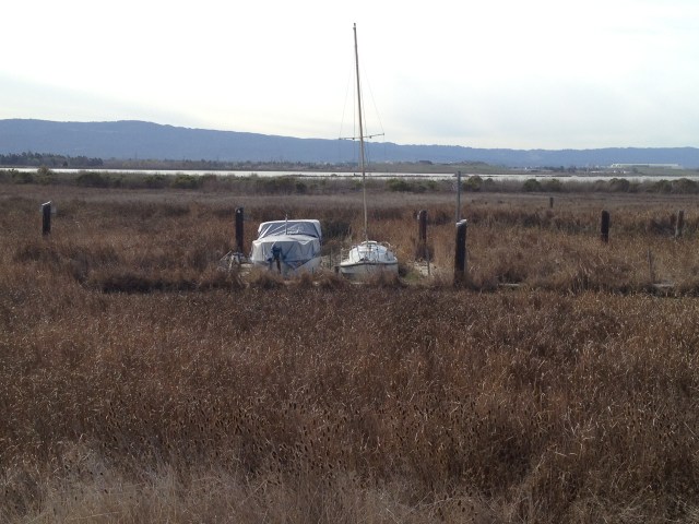
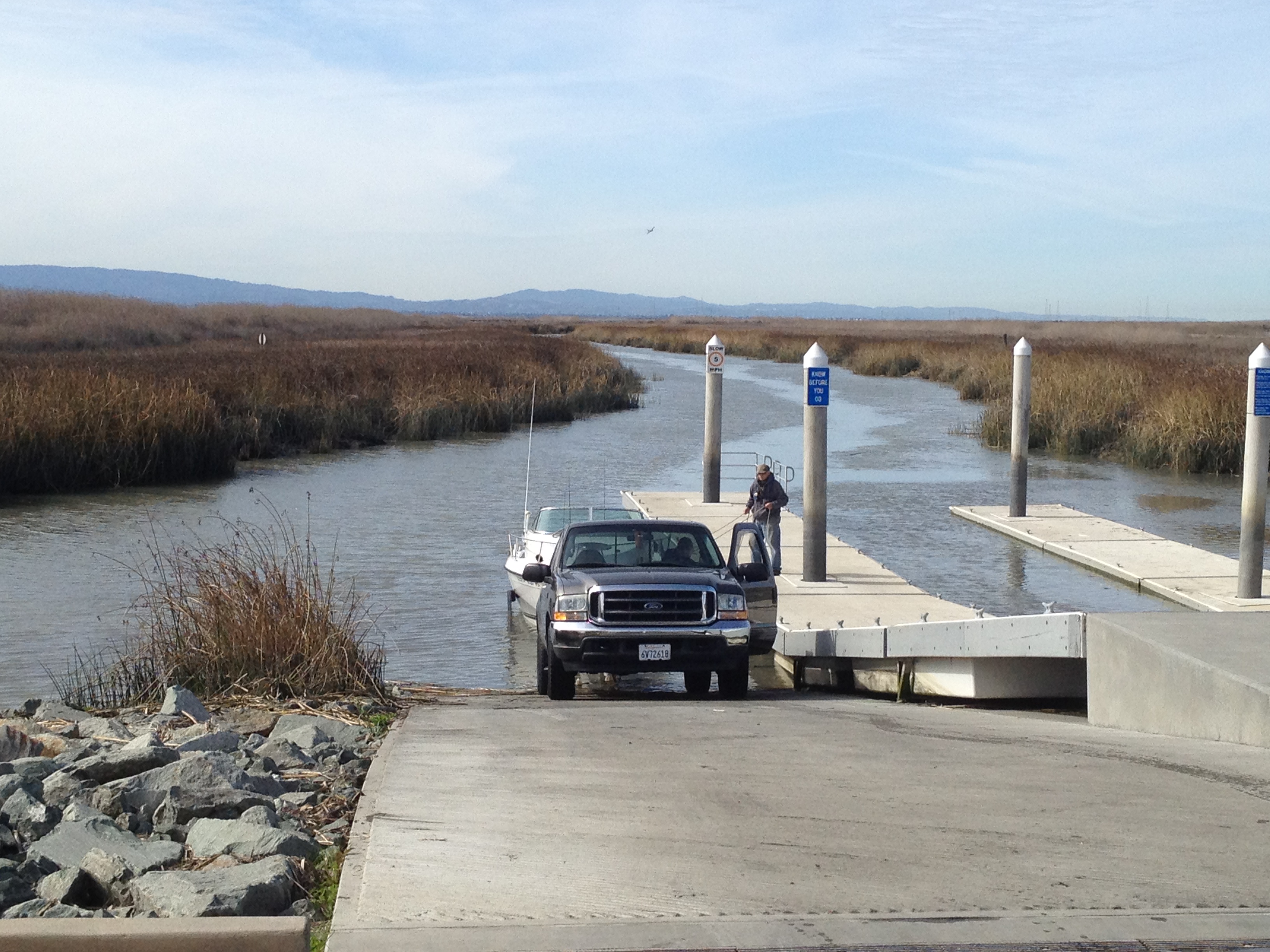
…plus a very new boat launch for day use only

IMG_8854

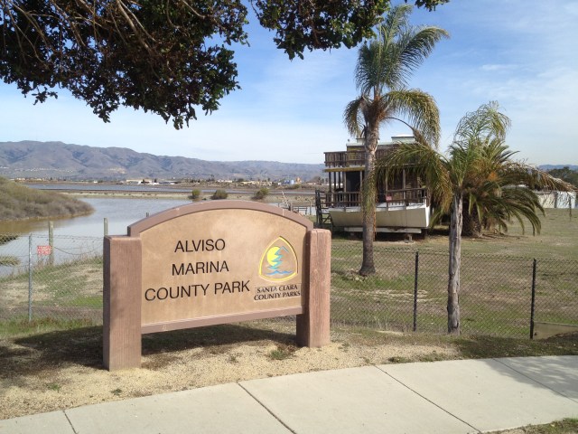
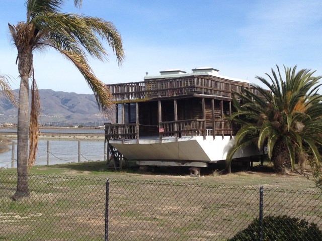
On your approach to the Marina (which is also a great spot for hikes and bike rides on the levees, with parking, restrooms, and water) you may notice the “stranded” house boat. This has been here for 20 years that I know of… (Eric noticed Noah’s Ark too! http://www.sanjose.com/underbelly/unbelly/Alviso/alviso9.html)

IMG_8860

IMG_8861

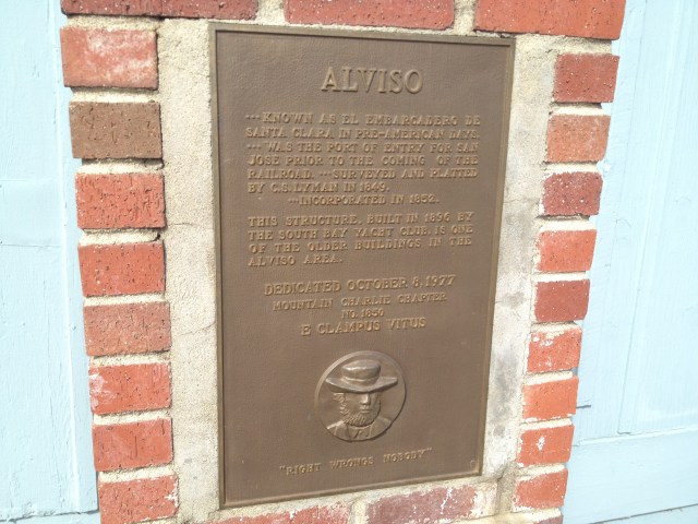
To the west (left) of the Marina is the “South Bay Yacht Club”, which has a long and storied history (http://www.SouthBayYachtClub.org and http://www.sanjose.com/underbelly/unbelly/Alviso/alviso10.html). This is a good place to notice that the Yacht Club is on the inland side of a high levee. The elevation of Alviso has been dropping over many decades. Strong winter storms used to occasionally cause the Guadalupe River to flood the town. (Despite the levees, this area does have flood potential. You may notice that the newer homes are built a bit higher than the street level. 1983 flood: http://www.sanjose.com/underbelly/unbelly/Alviso/wet.html)

IMG_8840

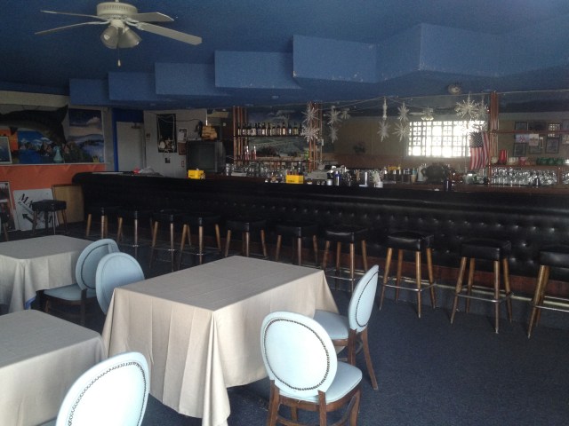
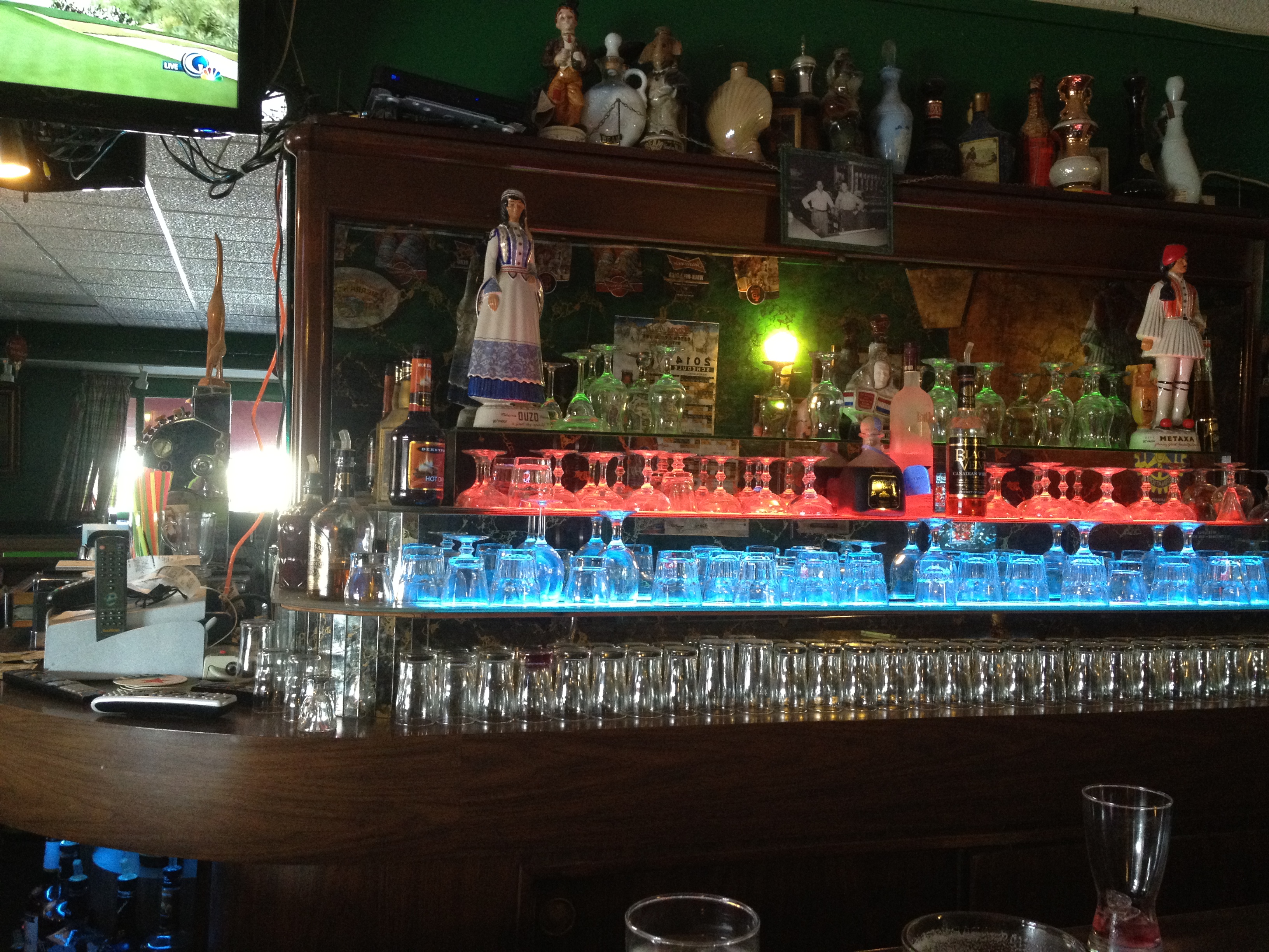
Years ago, before the more prominent signs discouraging visitors from peeking in the windows, I caught a glimpse of the beautiful bar inside, as did Eric: http://www.sanjose.com/underbelly/unbelly/Alviso/sybc3.html)

IMG_8846

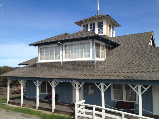
Yes, “E. Clampus Vitus”! The source of many interesting markers in California, particularly in the Gold Country! (This marker being in the right side of the SBYC building)

IMG_8847

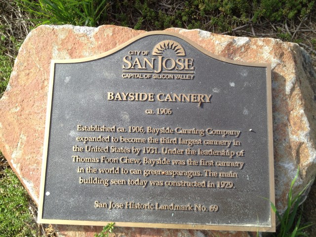
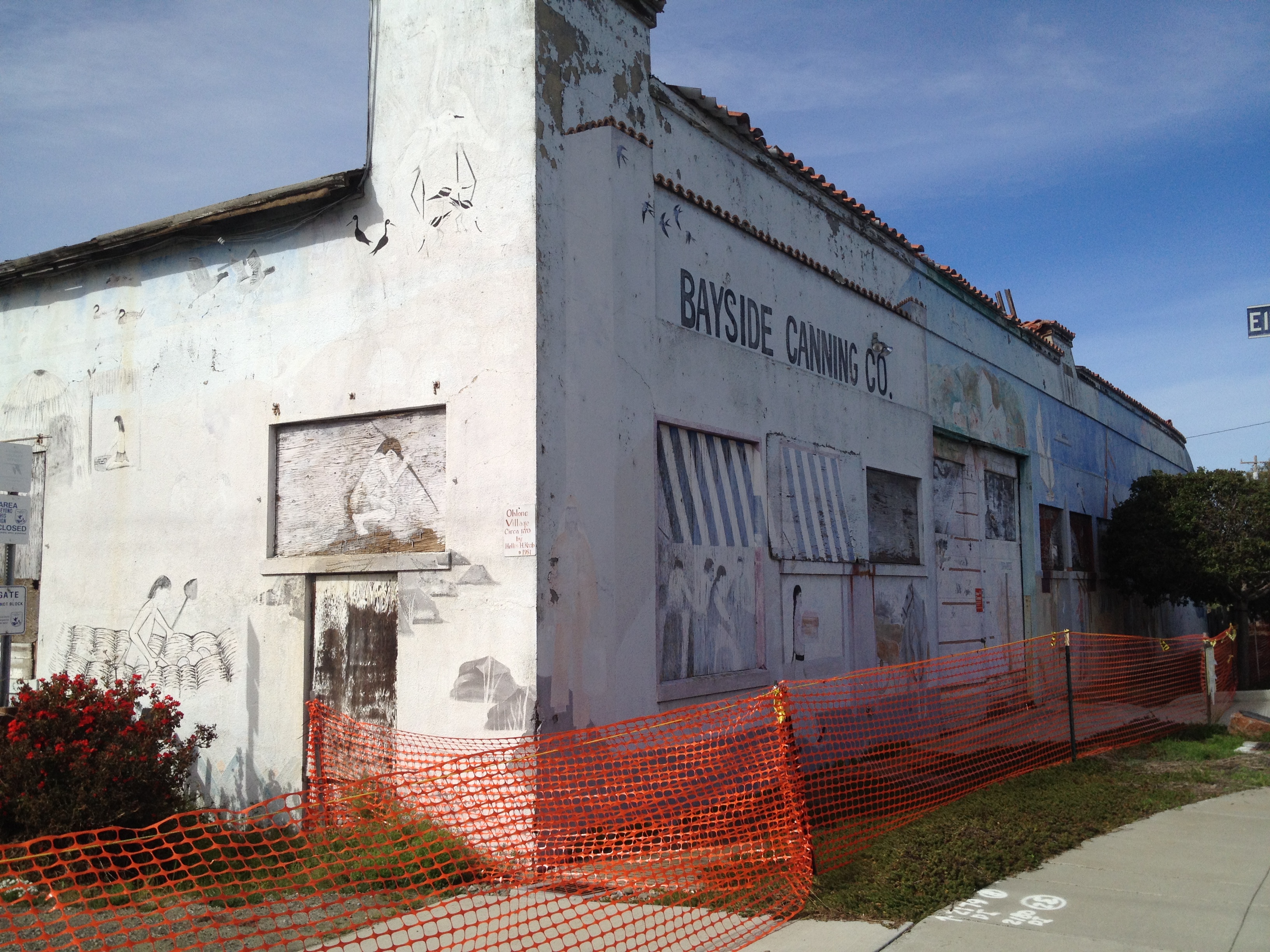
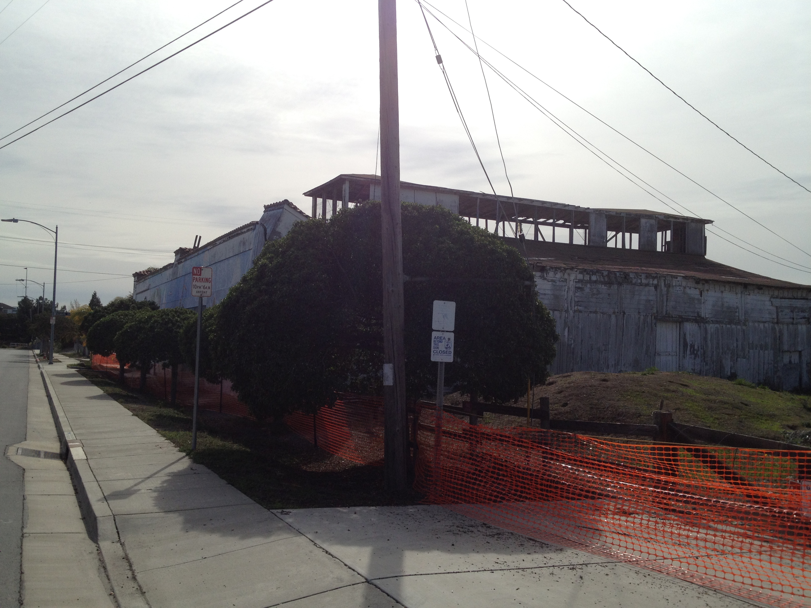
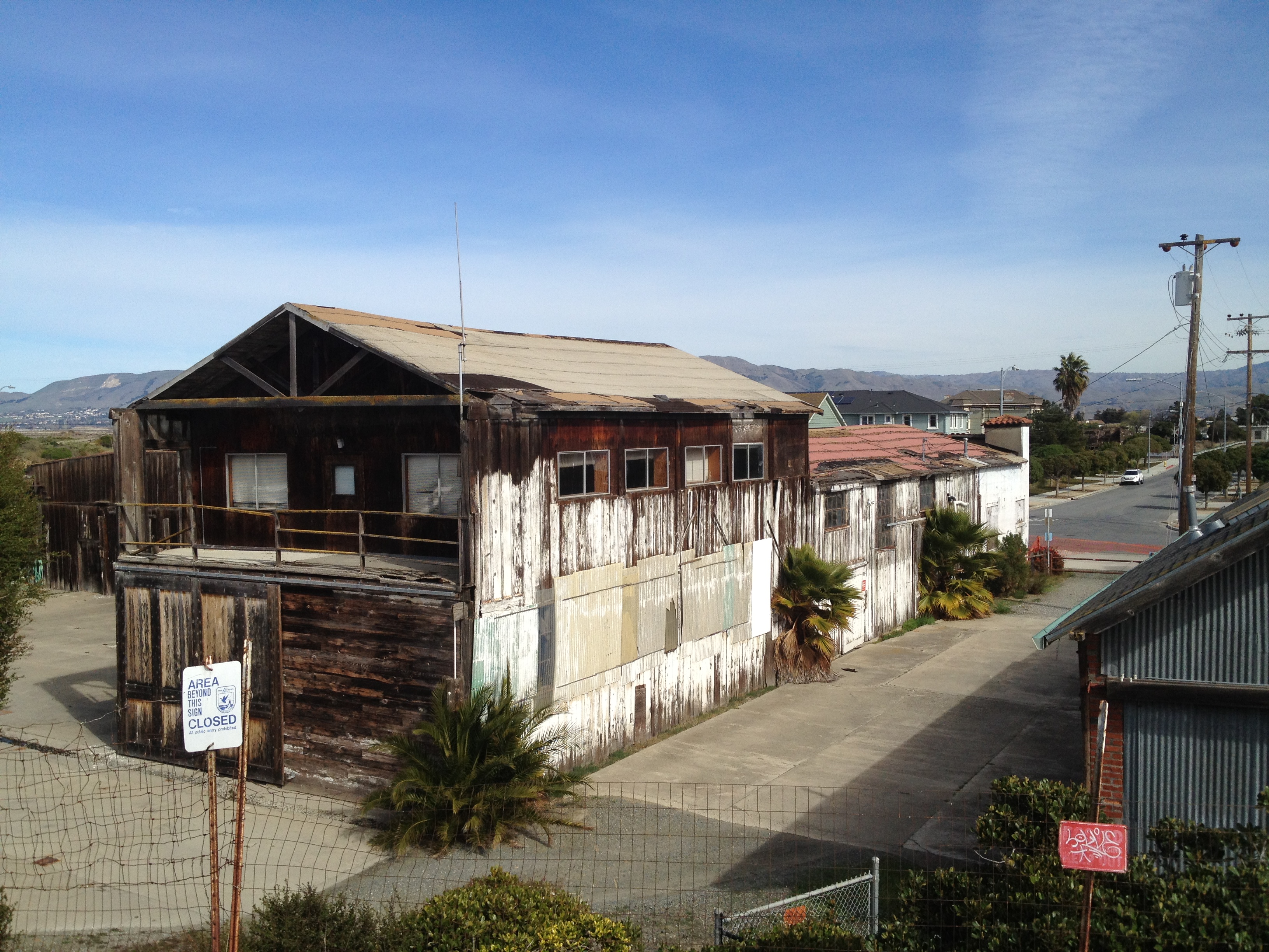
Between the SBYC and the Marina lies the shell of the former “Bayside Canning Company”. (Eric’s write-up: http://www.sanjose.com/underbelly/unbelly/Alviso/alviso12.html)

IMG_8865

IMG_8866

IMG_8862

IMG_8852

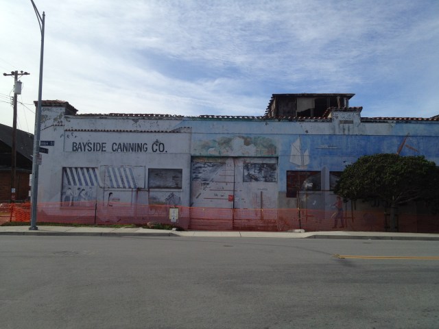
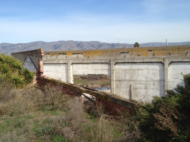
It’s noteworthy that it was the 3rd largest cannery in the U.S. at one point, as well as being owned by a Chinese-American.

IMG_8864

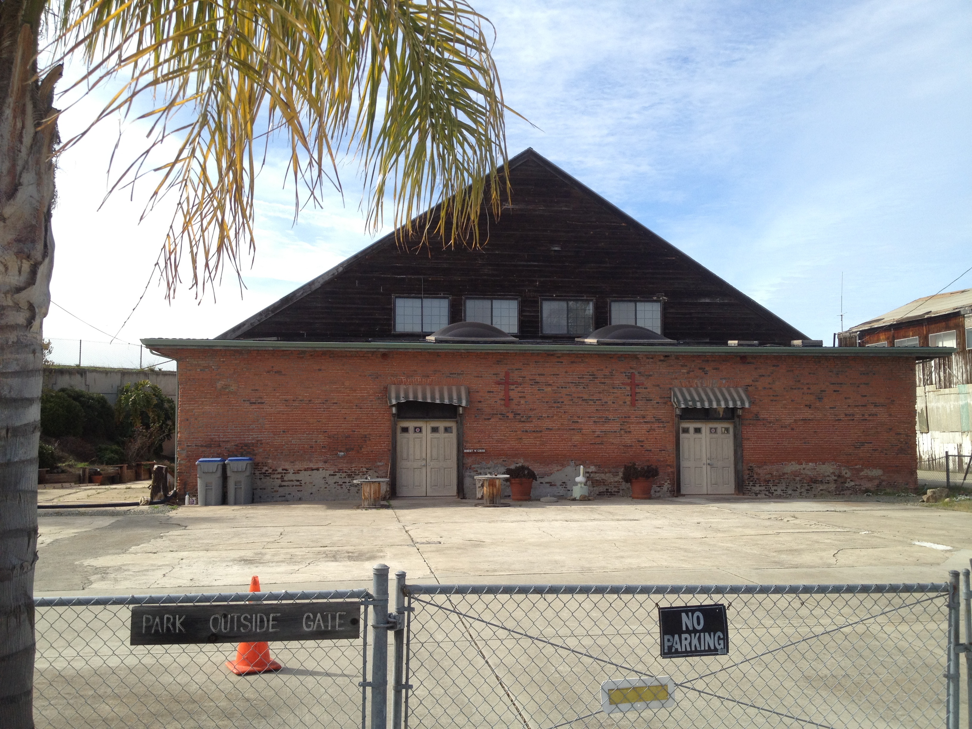
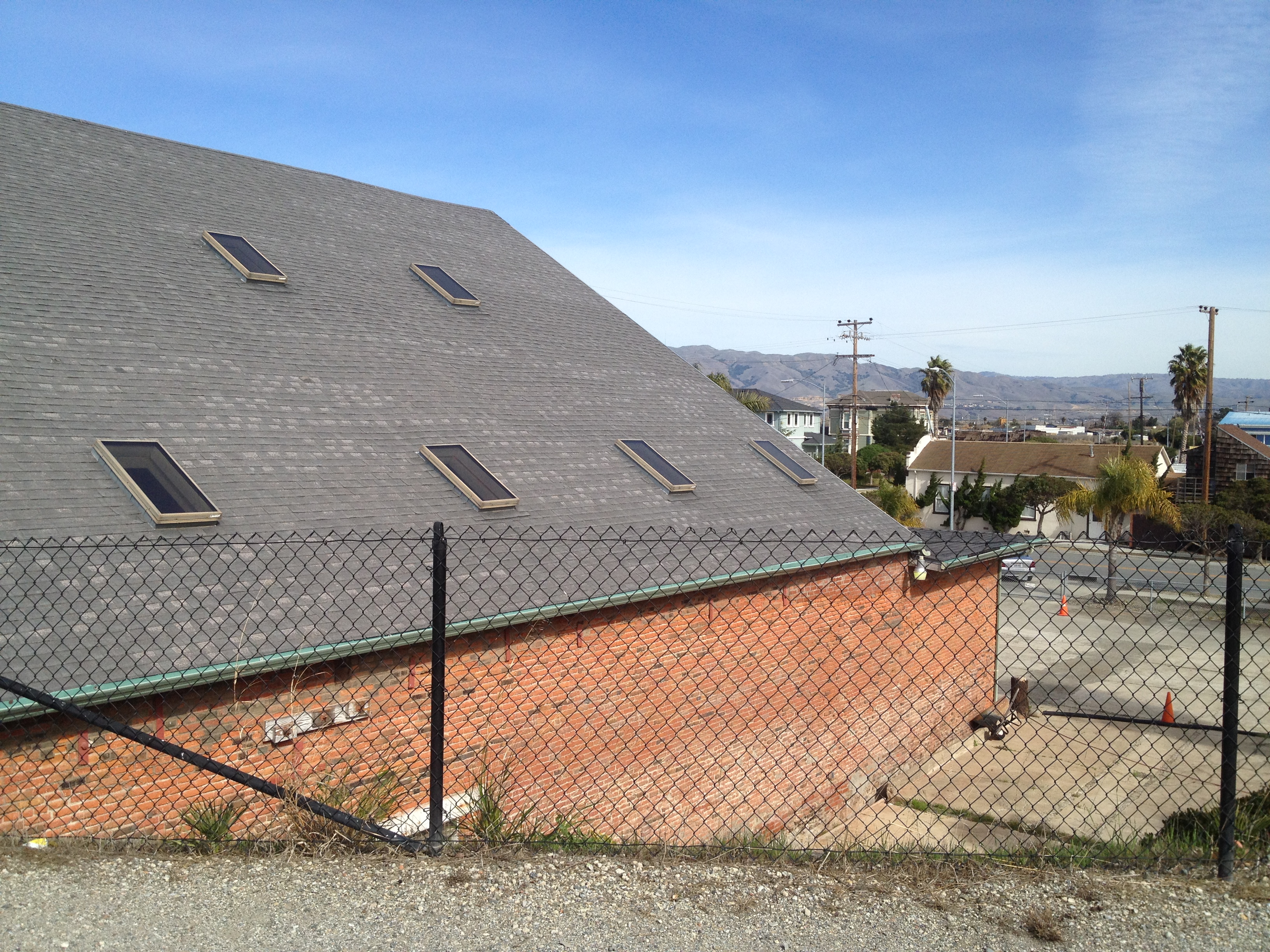
To the left (south) of the cannery is a large and odd brick building, marked as the “Union Docks and Warehouse”.

IMG_8868

IMG_8870

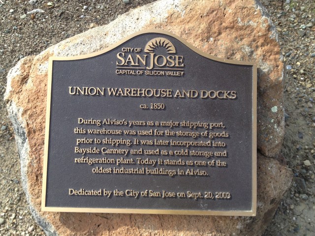
It’s now a private residence, which you can look down upon from the public levee walkway.

IMG_8849

IMG_8850

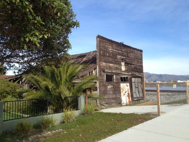
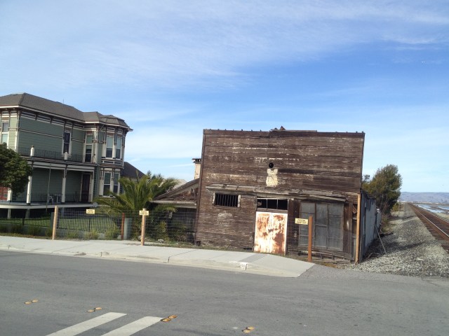
Just before the active railroad tracks leave town to the north, there’s an easily overlooked old place on the left. Eric Carlsen refers to it as “Laine’s Grocery”, though it had several incarnations before that, as well as a newer, yet faded, “tattoo parlor” sign since Laine’s closed around 1960. http://www.sanjose.com/underbelly/unbelly/Alviso/structure.html

IMG_8839

IMG_8873

IMG_8877

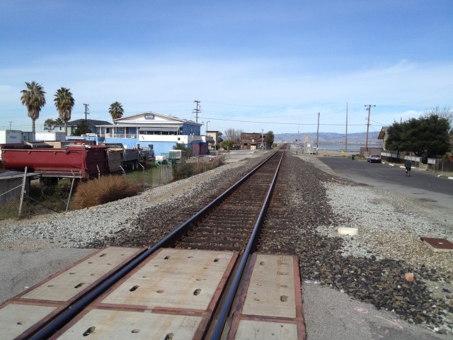
To the right of Laine’s Grocery, the trains zip northward from Alviso, through the mysterious “Drawbridge” (http://www.sanjose.com/underbelly/unbelly/Draw/draw1.html). To the left of Laine’s lie a few stately old homes. The large yellow one has a marker out front. (Eric’s write-up: http://www.sanjose.com/underbelly/unbelly/Alviso/structur3.html)

IMG_8887

IMG_8884

IMG_8886

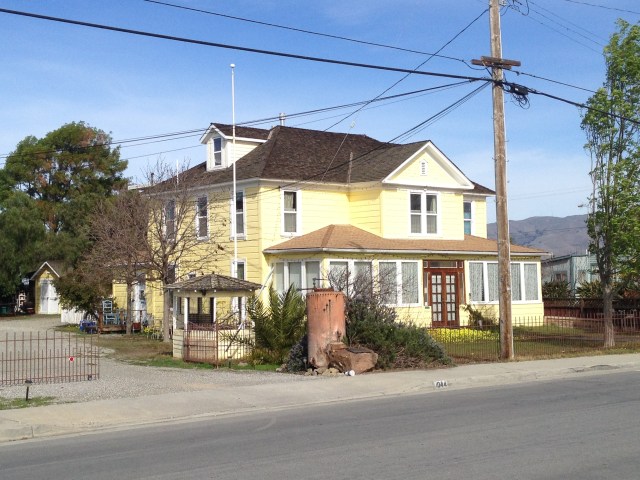
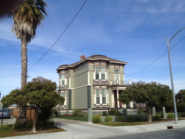
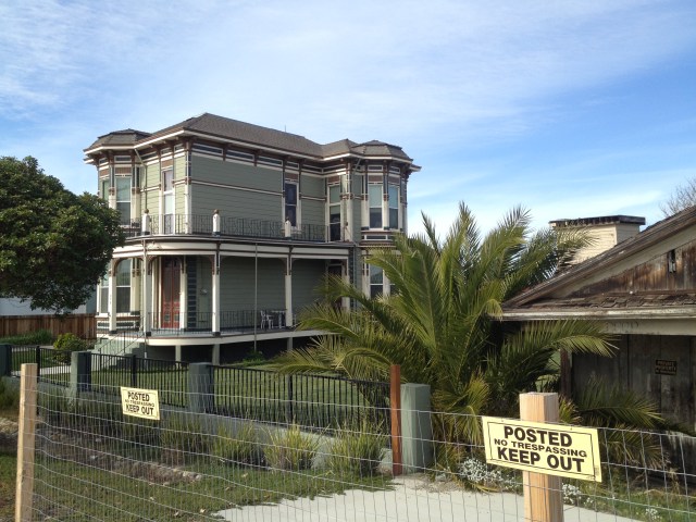
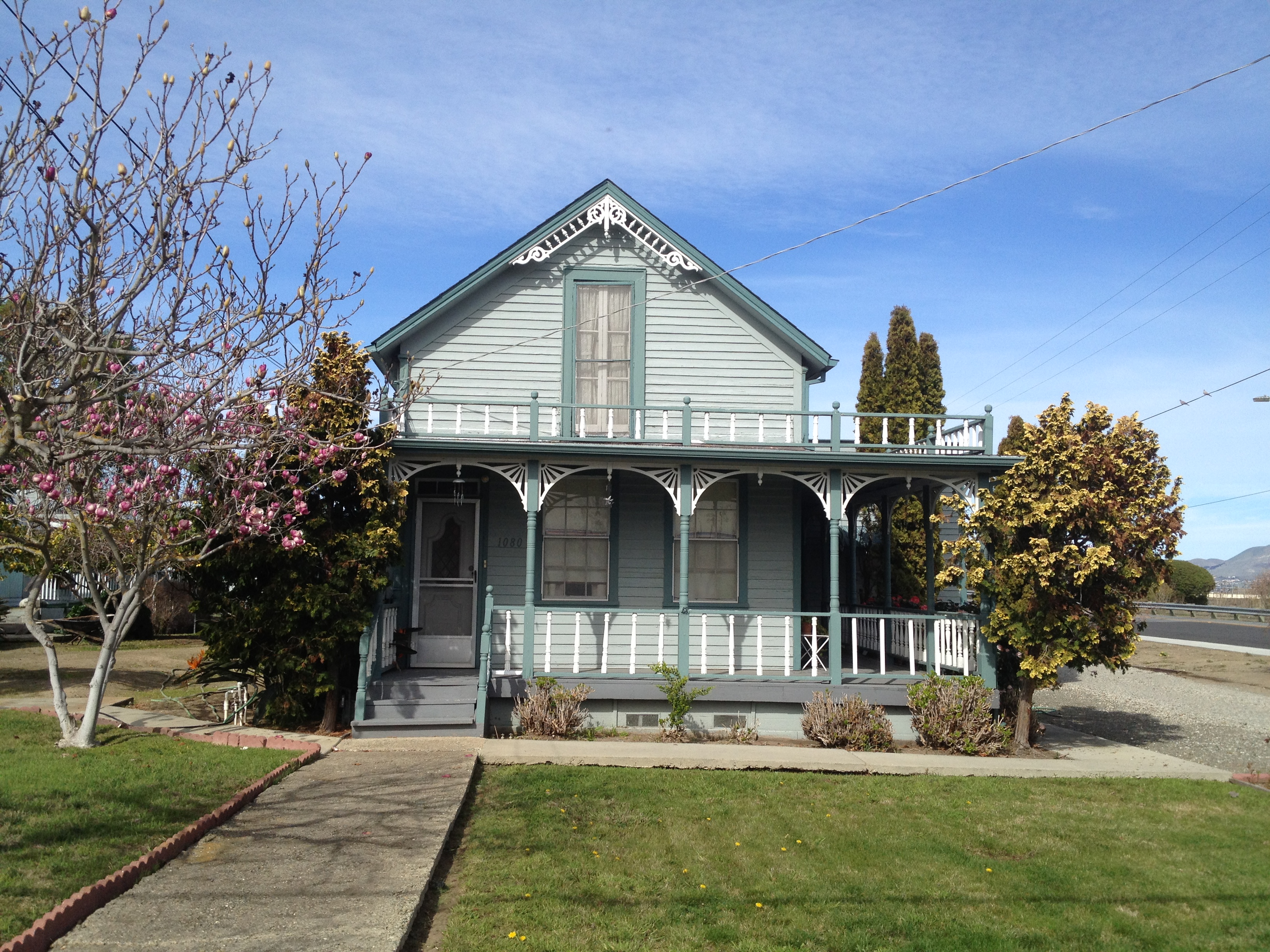
The other two homes of note, on the same block, are the very stately and tall 1887 Italianate “Tilden-Laine” home http://www.sanjose.com/underbelly/unbelly/Alviso/structur2.html

IMG_8872

(You can see a bit of “Laine’s Grocery” on the right side of this photo.)

IMG_8874

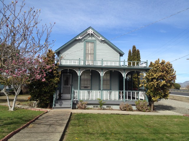
…plus a cute gray cottage. (Perhaps you like it better in “hot pink”? http://www.sanjose.com/underbelly/unbelly/Alviso/marthouse.html )

IMG_8888

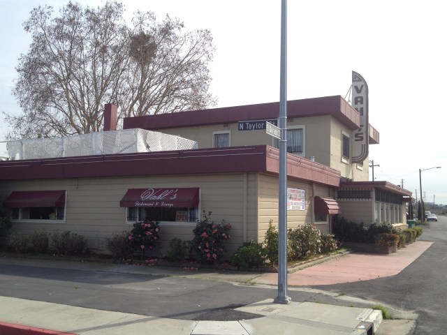
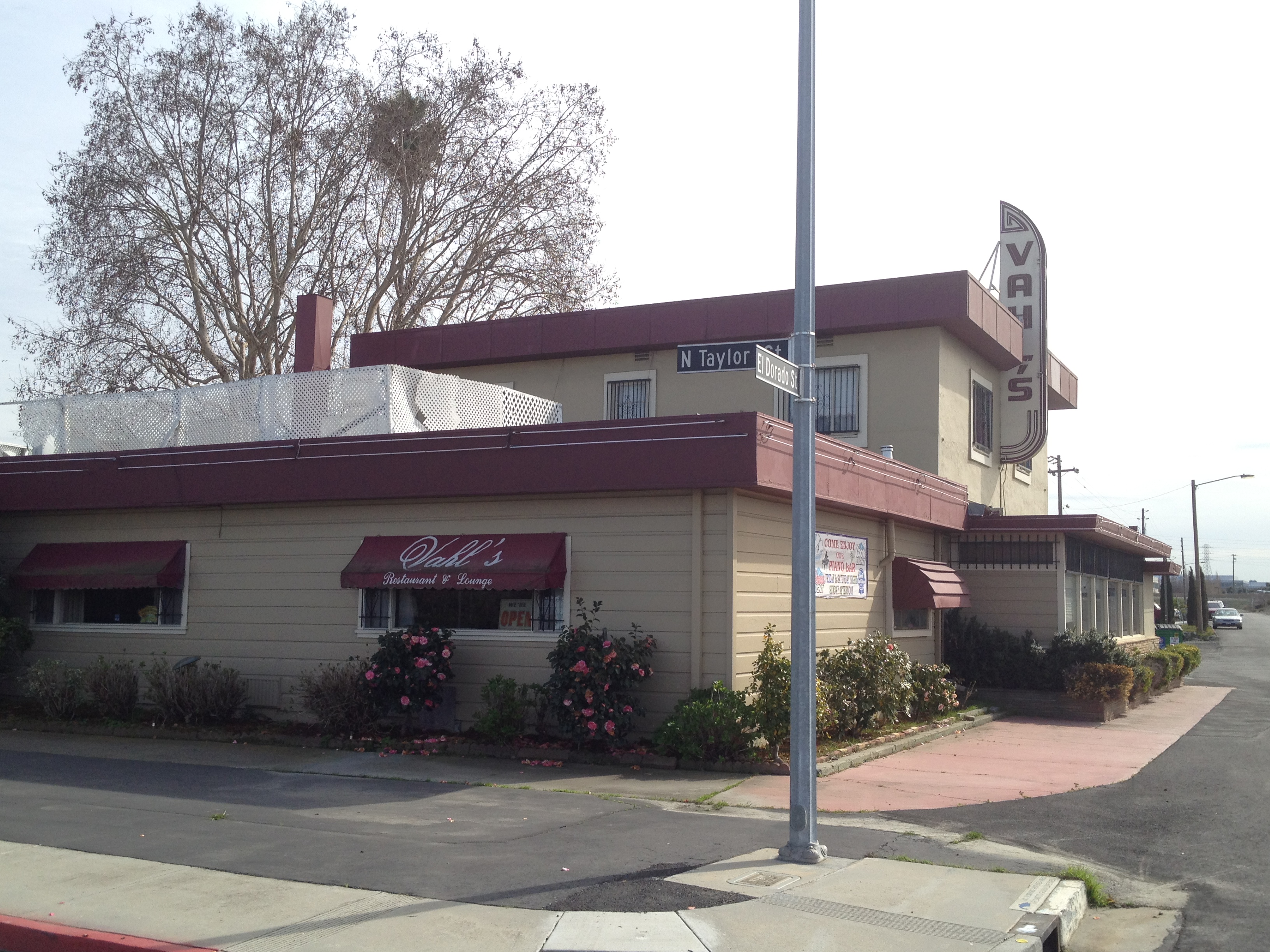
A bit south, along the eastern side of the tracks, lies the historical “Vahl’s Restaurant”. http://www.yelp.com/biz/vahls-restaurant-and-cocktail-lounge-alviso (Eric Carlsen’s write-up: http://www.sanjose.com/underbelly/unbelly/Alviso/vahls.html)

The whole building is a time warp from the 1950’s, even including one of the bartenders (“Frank”) and the “piano man” who plays once or twice a week.

IMG_8883

IMG_8837

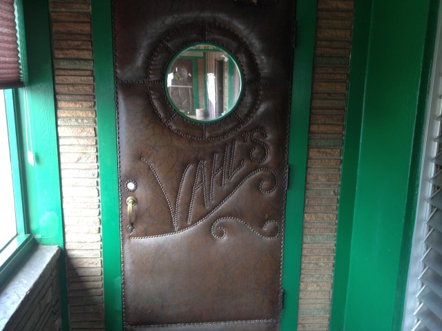
The back door, on your way to the restrooms, has a “classic” padded and patterned vinyl door!

IMG_8836

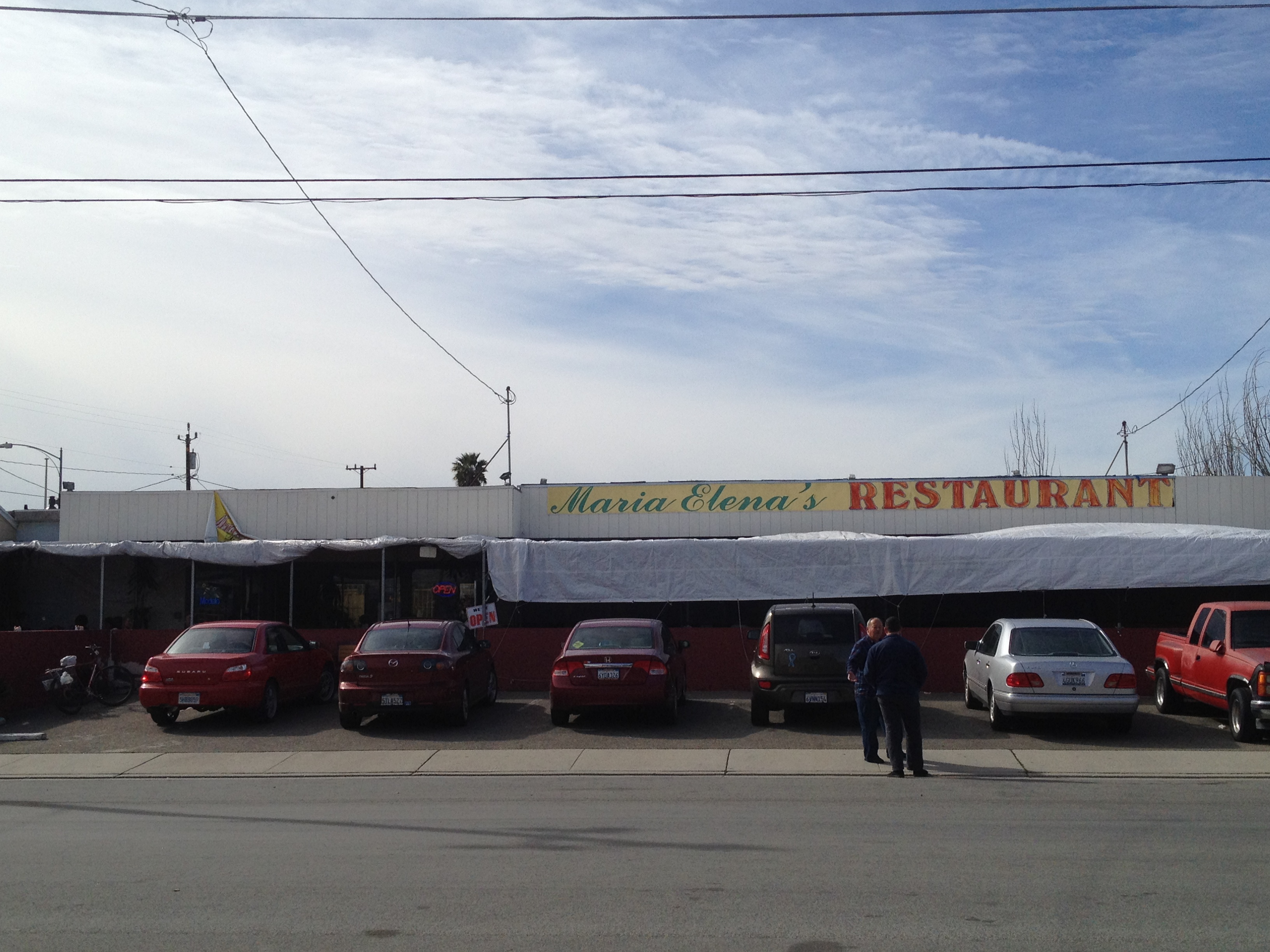
In addition to Vahl’s quaint bar (and Vahl’s restaurant, which I can’t rave about), Alviso has the very popular Maria Elena’s Restaurant. http://www.yelp.com/biz/maria-elenas-restaurant-alviso (Eric’s write-up: http://www.sanjose.com/underbelly/unbelly/Alviso/alviso7.html)

IMG_8879

…as well as the now closed “Marina Restaurant”. It used to be called the “Marina Seafood Grotto”, then turned into a Korean Restaurant shortly before it closed around 2010. http://www.yelp.com/biz/marina-restaurant-and-bar-alviso (Eric’s write-up: http://www.sanjose.com/underbelly/unbelly/Alviso/grotto.html)

IMG_8875

..a photo thru the glass door of the Marina, frozen in time, 4 years without a customer except the “Ghosts of Alviso”!

IMG_8876

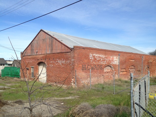
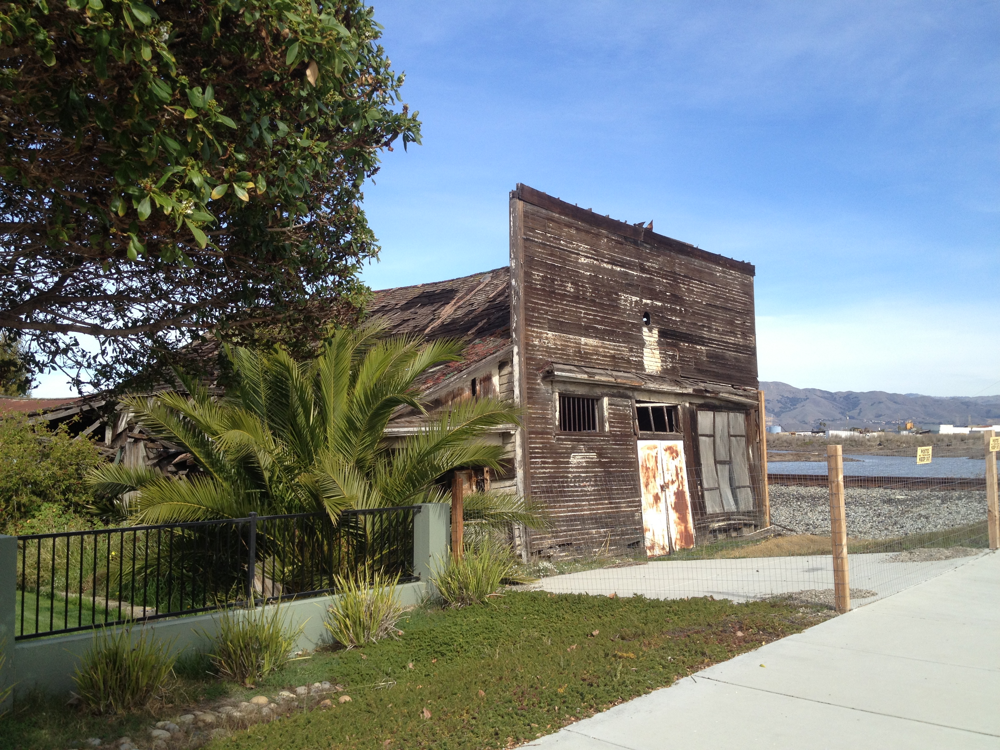
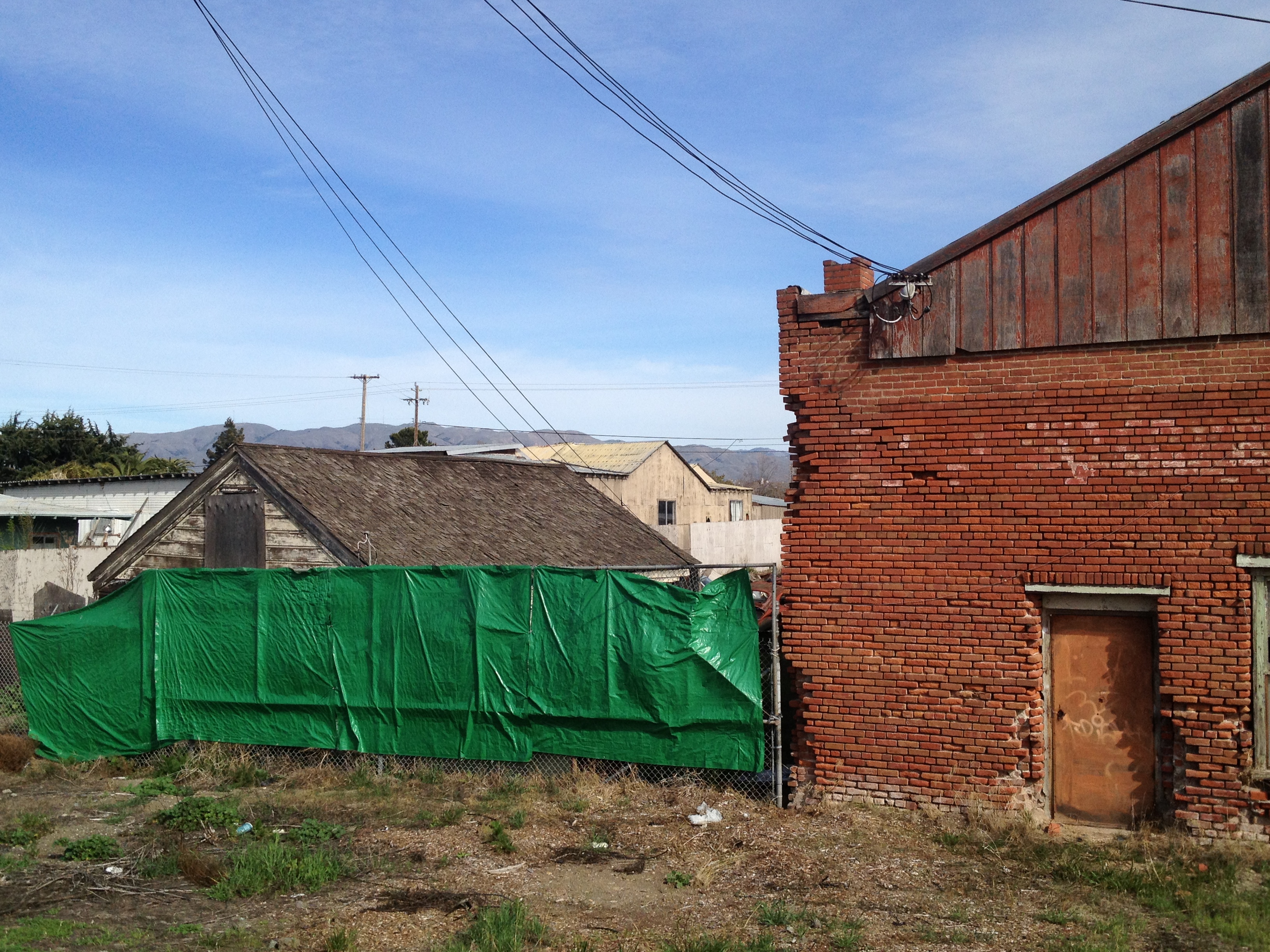
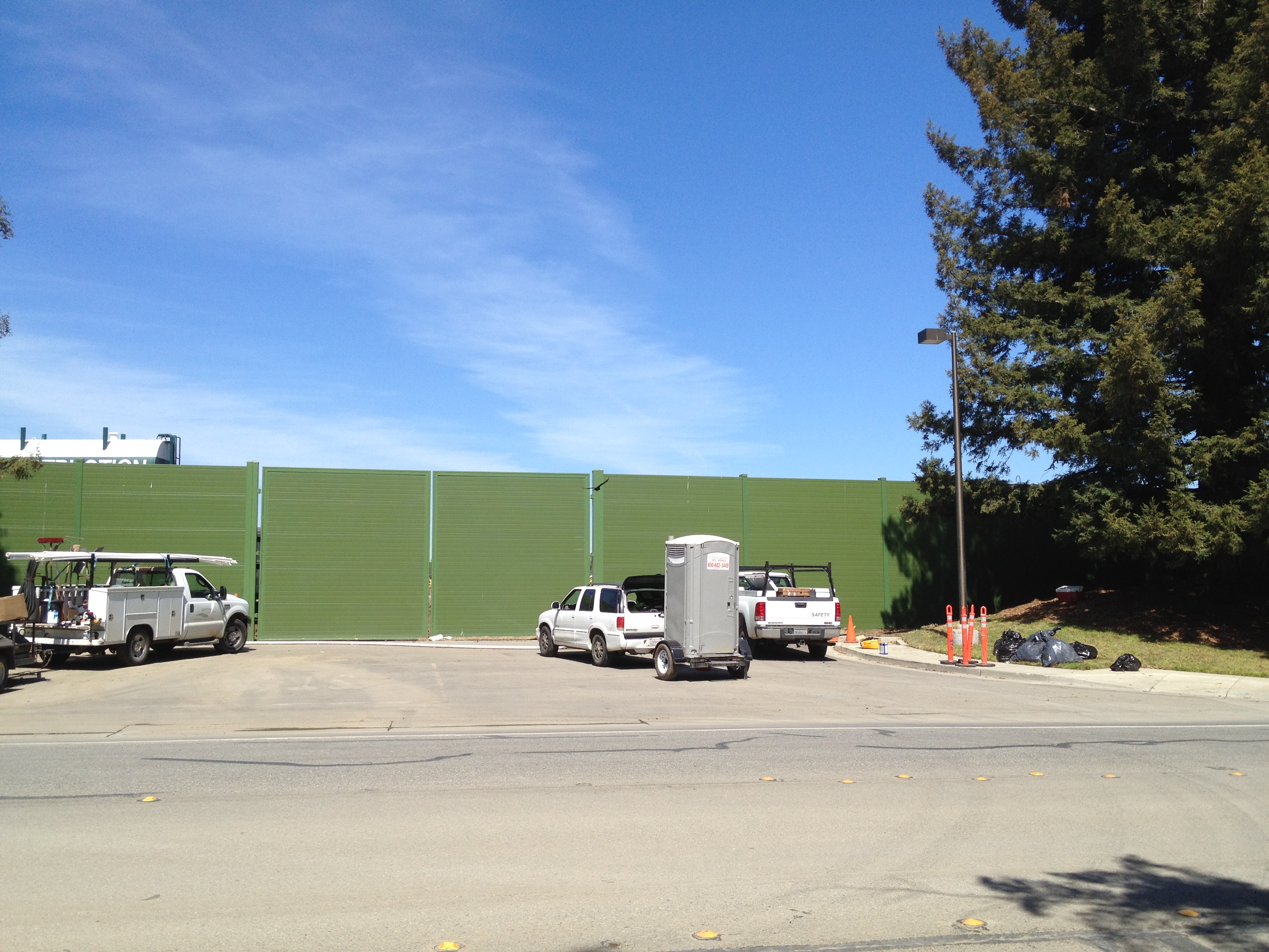
Last, but not least, along the eastern edge of the tracks, a bit south of Vahls, lies the crumbling H.G. Wade warehouse and the neglected home next door. You may have already spotted the warehouse, depending which way you entered town. Several “Western” movies were said to have been partly filmed at this warehouse. (The house is behind the green tarp. It used to be more visible, including when Eric took photos: http://www.sanjose.com/underbelly/unbelly/Alviso/hornhouse.html )

IMG_8895

IMG_8891

IMG_8894

That’s it! Enjoy your visit to Alviso! Be sure to read-up on the SJ Underbelly links before you go, as well as look for the painted mural map at the main crossroad in town, near Maria Elena’s Restaurant.

If you have any interesting stories or pictures, please be sure to leave a comment!

Posted in Uncategorized | 17 Comments

Merrell Moab Ventilator – “Long Term Test”!

I’ve been wearing exclusively “Merrell Moab Ventilator” hiking shoes for about 3 years now. Love ’em! http://www.merrell.com/US/en/Moab-Collection

IMG_0202

After a little over a year of hard use, about 3 days a week, the soles were showing some wear in the center, as is to be expected. (The laces were replaced once, after an accidental encounter with the moving parts of my mountain bike! No injuries, no stories to tell…)

IMG_0204

Honestly, I didn’t *have to* replace these shoes. I *wanted* to! The materials and the durability mean I could use these for many more happy miles. The “uppers” are almost like-new, with the materials and sewing, including the eyelets, still being in excellent condition. “Why” then? Well, there are some really steep hikes in the San Francisco / Silicon Valley area and I’m accustomed to excellent traction on trails in places like the Ohlone Wilderness trek to Murietta Falls (https://alpharoaming.com/2014/03/12/murietta-falls-in-the-ohlone-wilderness/)

I have been quite happy with my 2 prior pair. MUCH better than 2 other brands I’ve owned in the past where the different layers of material in the soles started separating. I bought the same ones again, this time I chose the color “Walnut” instead of “Sand”.

IMG_0205

Isn’t it always fun to open up “shiny new stuff?”

IMG_0206

The comparative wear on the soles is apparent, and quite normal given the long, steep, and rocky hikes I often subject them to.

IMG_0209

Ready for my next outing!

If I hadn’t had these twice before, I would be sure to wear them around town for a few days, or on a few short short hikes, before venturing on a long trip. It’s always good to watch for “hot spots” or other surprises. My foot is more-or-less a typical Men’s 11. Size 11.5 seems to work well for me, with some seasonal variations in my choice of socks.

IMG_0207

Out with the old, in with the new! They’ve served me well. Cool, light, comfortable, durable, excellent traction, and even able to scare away an occasional rattlesnake! https://alpharoaming.com/2012/09/26/rattlesnake-adrenaline-rush-tie-down-peak-at-henry-coe/

IMG_0208

I summary, they work great for me, as you can see by my repeat purchases. Comfortable right out of the box! Try them on at your nearest retail store and see if they work for you! http://www.merrell.com/US/en/Moab-Collection

Posted in Uncategorized | 2 Comments

Jasper Ridge Biological Preserve (Stanford University)

This past thursday I took a docent-led tour, with 3 other friends, at Stanford University’s Jasper Ridge Biological Preserve. http://jrbp.stanford.edu/

It’s located very close to Highway 280, off of Sand Hill Road. If you’re passing-by on 280, and look at the ridge behind the Stanford Linear Accelerator building, you now know the name of that wooded ridge!
https://www6.slac.stanford.edu/
http://en.wikipedia.org/wiki/SLAC_National_Accelerator_Laboratory

IMG_9979

I first heard about this interesting place because I was watching the Santa Cruz Puma Project (http://santacruzpumas.org/) via Twitter (@WeiWei82). They do a fascinating job of collaring and tracking the local population of Pumas/Mountain Lions/Panthers/Cougars/Catamounts. (5 names for the same species, “Puma concolor”!).

One of the related Tweets, or Re-Tweets was from someone who posts game camera photos for Jasper Ridge (@JRWildlife). I started watching those Tweets and looked into their work. To make a short story long [sic], I noticed they give public tours, and I signed-up myself and a few interested friends: http://jrbp.stanford.edu/tours.php

Meeting at a “secret” gate, on Sand Hill Road, our docent led us up the gravel road

IMG_9981

…to a large and airy research building, built in 2002:

IMG_9985

Inside there were offices, a library, a kitchen area, a sitting area, and some other areas we did not see…

IMG_9988

IMG_9989

A small glass case with some local artifacts:

IMG_9992

After signing the obligatory “liability waiver” and a quick safety briefing about staying together on the trail and “no petting the rattlesnakes, ticks, mountain lions, and poison oak”, off we went!

IMG_9993

Our docent, Ann, was really great! She earned her Master’s from Stanford many years ago on this very property. She really knew her plants and animals and enjoyed sharing it with us. We couldn’t have asked for more!

A portion of San Francisquito Creek:

IMG_9998

Beautiful trails for a few miles (with a low frequency hum coming from the direction of SLAC)

IMG_0007

IMG_0008

Some unexpected surprises, that would not be left untouched in a public park!

IMG_0010

Replicas, I’ve been told:

IMG_0022

The lower face of the Searsville Dam, with some small underwater “critter traps” and 3 species of dragonflies and damsel flies entertaining us! (The dam is a “spillover” dam, which we were told is quite a sight in the rainy season!)

IMG_0005

We were surprised to see some “Tafoni” on our walk. We were all familiar with the tafoni formation in the El Corte de Madera Open Space Preserve http://www.openspace.org/preserves/pr_ecdm.asp

I had also recently been made aware of another formation, as well (includes links to explain “tafoni”): https://alpharoaming.com/2014/02/26/neilyoung/

This one, not being up in the hills, was an unexpected pleasure!

IMG_0015

IMG_0020

We later circled around on the trails and walked across the Searsville Dam. It was quite a dropoff, with only an iron pipe railing.

Searsville Dam Photo courtesy of Anne Keller

Searsville Dam
Photo courtesy of Anne Keller

IMG_0025

That’s it! We thanked our docent, and left a cash donation (Donation envelopes were at the sign-in desk, but there was no specific request or pressure. We thought it would be a good idea!) A great, leisurely walk-and-talk of about 2 hours. Now when I pass by Sand Hill Road on 280, I’ll look beyond the SLAC Accelerator building at the ridge and know what cool stuff is just on the other side!

Posted in Uncategorized | Leave a comment

Orestimba Wilderness, Rooster Comb, Robison Creek @ Henry Coe State Park

A few photos from a recent adventure in Henry Coe State park!

It’s a great opportunity on summer weekends to drive 7 miles further into the park than you normally can. Dowdy Visitor’s Center: http://coepark.net/pineridgeassociation/planning-your-visit/visitor-centers-and-park-entrances/dowdy-ranch-visitor-center

(It is also possible to park your car at the bottom, at Bell’s Station on Highway 152 any day of the year and hike or bike those 7 miles. It’s about 80 minutes up, for a reasonably strong cyclist, and alot shorter going down, shouting “wheeeee!”)

The sign down at Highway 152:

IMG_9853

Tie Down Peak, taunting me once again. (https://alpharoaming.com/2012/09/26/rattlesnake-adrenaline-rush-tie-down-peak-at-henry-coe/) A few miles north of the Dowdy Visitor’s Center:

IMG_9866

The last little creek crossing before Orestimba Corral. Quite dry compared to previous years!

IMG_9876

Orestimba Corral and a drinking water barrel that was to be used at Backcountry Weekend.

IMG_9877

No flowing water for many miles, but there are still some inviting “puddles”:

IMG_9887

About 5 miles past Orestimba Corral and you’ll see the prominent “Rooster Comb” come into view:

IMG_9892

The “Rooster Comb Ranch” owns the creek valley in this area. You’ll need to take a trail up the flank of Rooster Comb:

IMG_9897

“Mariposa Lillies” are common in the late spring:

IMG_9900

A “typical” stretch of trail headed up Rooster Comb. (It’s wooded on the more northern part of the trail)

IMG_9901

Getting a bit closer:

IMG_9902

Looking down into the creek valley. Note the patch of green grass across the way. It appears to be irrigated:

IMG_9908

The turnoff to head up the the top of Rooster Comb:

IMG_9909

Flowing water in the valley north of Rooster Comb…the first I’ve seen!

IMG_9916

Almost to the north-east boundary of the park:

IMG_9918

Robison Creek, just above where it enters Orestimba Creek:

IMG_9919

Just to the left, looking upstream:

IMG_9920

Signs, just inside the park boundary:

IMG_9922

I was looking for “Robison Falls”, as marked on the map. There was flowing water, obscured by alot of tall grass and poison oak. I think this is the area…maybe I missed it. I have no idea and I can’t find a picture of it. The rock (below) is located at N 37° 16.909 W 121° 21.733 I certainly didn’t see any dropoffs as large as Pacheco Falls (https://alpharoaming.com/2014/04/28/pacheco-falls/) or Grizzly Falls.

IMG_9925

Update, May 17, 2014: Based on discussions with a few others, and a peek at Google Earth, the falls are ~600 feet upstream of the big rock mentioned above. Chris Kangas provided this photo and coordinates from April 2009:

Robison Falls, April 2009 Photo credit: Chris Kangas

Robison Falls, April 2009
Photo credit: Chris Kangas
N 37° 16.893 W 121° 21.853

As I was heading back, I wandered off the road/trail to take a peek at this small pool for fish and other doomed creatures. I noticed footprints and a set of bicycle tracks:

IMG_9944

More mind-numbing miles back!

IMG_9949

Short “photo essay”, unlike my usual wordier ones. Have fun, and prepare VERY well for heat, sun, injury, rattlesnakes… (this is a starting point for what I carry: https://alpharoaming.com/2013/12/02/my-own-23-essentials-for-comfort-and-survival/ )

Posted in Uncategorized | 1 Comment

Nisene Marks State Park & “Oh! What’s This? A Brewpub?” (Sante Adairius)

IMG_0460

Imagine the peaceful serenity and killer hillclimbs that can be found in Henry Coe State Park, but this ride includes one of the most innovative brewpubs around!

You could do a big ride in Henry Coe State Park (like this recent one https://alpharoaming.com/2014/04/28/pacheco-falls/ ) and then go to http://www.eltorobrewing.com/ on the way home. You could do a 3 day trip and bring your own beer (https://alpharoaming.com/2013/10/05/bikepacking-henry-coe-state-park-day-1/) ….or you could park your car at 2600 feet elevation in the Santa Cruz Mountains and (mostly) coast downhill through the redwoods and have a beer before you turn around and go back! On sunday I did just that, with the destination being the 12:00 opening time at http://rusticales.com/

I’ve done this trip twice before, the most recent tiem being just over a year ago http://www.everytrail.com/view_trip.php?trip_id=2090143 The first time has better photos and a slightly longer route http://www.everytrail.com/view_trip.php?trip_id=2044951

I parked the car, once again, on Highland Way at Buzzard’s Lagoon Road, between Los Gatos and Corralitos.

IMG_9727

..and soon entered the park. Other than mountain bikers and a few scattered residents, this entry point is quite unknown!

IMG_9732

I’m loving THIS sign! Bikes are OK, but not horses. A rarity around here! (I like equestrians, but given their sparse numbers and the large number of trails they’re allowed on and bicycles are not, there needs to some better balance. Cyclists don’t leave “steaming piles” on the trail and both contribute somewhat to erosion.)

IMG_9764

After cruising west, on a relatively flat stretch, it’s time to go thru a gate and start shouting “Wheeeee!”

IMG_9734

At a major trail junction, where the trail meets another trail coming from the Soquel Demo Forest, there’s a bench. My camera doesn’t capture it, but the Monterey Bay and the mountains of the Monterey Peninsula were visible on the horizon. The bench is sponsored by the Mountain Bikers of Santa Cruz.

IMG_9738

And a sign at the junction, immediately behind the bench

IMG_9740

There were definitely signs of spring, besides all the greenery. These something-or-others from the Iris family were a bit past their peak.

IMG_9743

….and DOWN we go some more! …2600 feet in total, almost to the beach!

IMG_9744

Ahhh! Here’s the mandatory “big tree picture”! This one was likely already burned-out inside during the logging boom about 100 years ago. The only ancient trees that were spared were the damaged ones and some that were in steep and inacessible locations. It is still quite healthy and alive.

IMG_9745

This bench is the “Sand Point Overlook” at an elevation of about 1600 feet. It’s a popular turnaround point for folks coming up from the main park entrance. The lower you go, the more people you’ll see!

IMG_9749

The turnoff to the Aptos Creek Trail and the 1989 earthquake epicenter. (Previous write-up here: https://alpharoaming.com/2013/08/12/bushwhacking-aptos-creek-near-santa-cruz-ca/)

IMG_9750

Almost there! This is taken from a side road, paralleling the coastal Highway 1.

IMG_9753

I arrived in a bit over 2 hours, well before their 12:00 opening time.

IMG_9754

Doors open at 11:55. First customer of the day!

IMG_9757

A very relaxing place!

IMG_9758

That’s it! (Did I mention that the car was still 20 miles UPHILL from here? 3 hours 45 minutes to return, beating my previous time by about 45 minutes)

Here’s my track: 41 miles, 6193 feet. The GPX file is downloadable in the “Tools” tab on the left http://www.strava.com/activities/137546261

Posted in Uncategorized | Leave a comment

The Apple “Spaceship”: 5 months later & traffic grumbling…

Back on December 6th I wrote about the beginning of the demolition of the old Hewlett-Packard buildings (…and Tandem Computers, which was purchased by H-P) https://alpharoaming.com/2013/12/06/new-apple-spaceship-campus/

Here’s a local article, with an aerial view, showing the site being completely stripped now. I decided to take another look! (My photos below are from the same direction, facing north from Pruneridge Avenue)http://www.bizjournals.com/sanjose/news/2014/04/30/apple-keeps-locking-up-new-property-even-as-its.html?ana=twt

At the northeast corner of the project, Tantau at Homestead looks much the same. Some digging in the street for utilities, some orange cones, and “the big green fence” hidden on the right.

IMG_9639

I love how signs are planted in the Bike Lane, especially the ones that say “Share The Road”!

IMG_9642

Yes, the “Big Green Walls” are everywhere, except in some places along Pruneridge Avenue, which will be closed and removed very soon.

IMG_9645

Along the “soon to be closed” Pruneridge Avenue, there are still old landscaping mounds, between the public sidewalk and the construction fence. These are convenient place to take a peek!

Trucks everywhere! A sign of prosperity and jobs.

IMG_9650

Looking south from Pruneridge, towards Highway 280, there is still some sorting of the debris to be done (the pile on the right). In the main area, north of Pruneridge, only piles of ground-up concrete remain (like the pile on the left).

IMG_9652

Notice carefully, looking to the right from my vantage point, you’ll see a gently curving line in the dirt, on the right side of the picture. This appears to be the beginning of the outline of the building.

IMG_9659

Looking to the left, the building outline is also clearly taking shape, with a curved line of orange flags. Note the quantity of drilling rigs and grading machines, all working at the same time.

IMG_9660

Flashback to 5 months ago when they were just starting to remove the old trees and a few of the buildings!

IMG_7792

Also from 5 months ago. Now part of the area being dug and graded.

IMG_7767

—————-

Here’s my rant about the traffic issues. If you’re not from the local area, you can ignore this! 😉

The Wolfe Road exit off of Highway 280, up to Homestead Avenue, has become a daily PITA! I now use Lawrence Expressway more often, which itself appears busier. The times I do take Wolfe, with the thought that maybe the traffic tie-ups are only during business hours, I’m wrong!

Southbound Wolfe, just north of Homestead has lost it’s third lane, as well as having lost one of the two “left turn lanes” onto Homestead. Northbound Wolfe has lost most of it’s “left turn lane” onto Homestead. The REAL bottleneck is when the remaining two northbound lanes are temporarily narrowed to one lane, and/or the right turn onto Homestead is slowed or blocked due to activity on Homestead.

Aaarrrggghhh! The good news is that Pruneridge is still open as an escape route to the right, but that will be closing and torn-up very soon…

Posted in Uncategorized | 1 Comment