Cycling Lake Tahoe (The Flume Trail, day 2)

We woke up at dawn on sunday morning (at our ugly, but convenient, campsite), and headed down the block for our morning coffee. From there, we packed-up our camping gear and headed to the Flume Trail shuttle for our 9:30 reservation. http://www.flumetrailtahoe.com/

…yes, we debated not using the shuttle, but as first time Tahoe cycling tourists who had to get back home that evening, it was the right choice. We had excellent directions, as well as advice about the trail itself.

IMG_6167

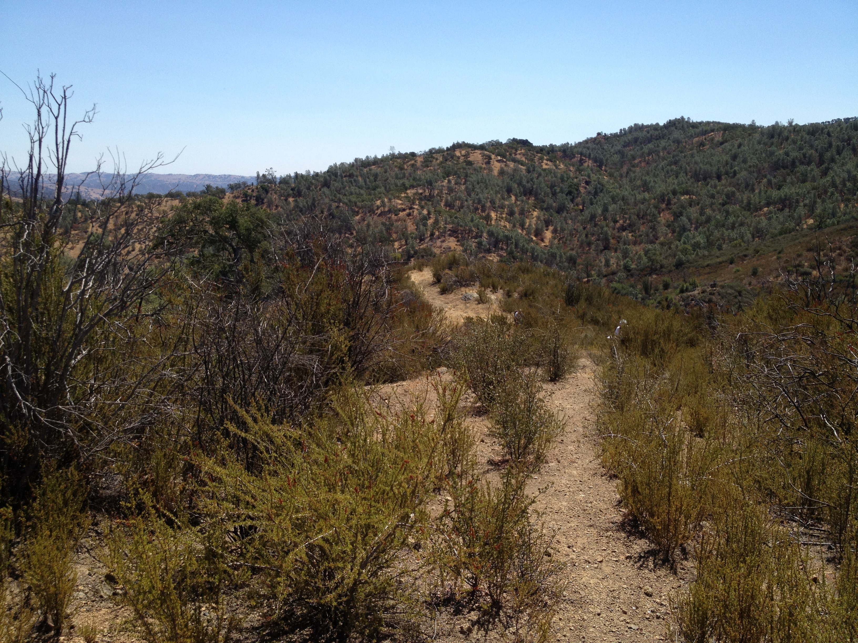
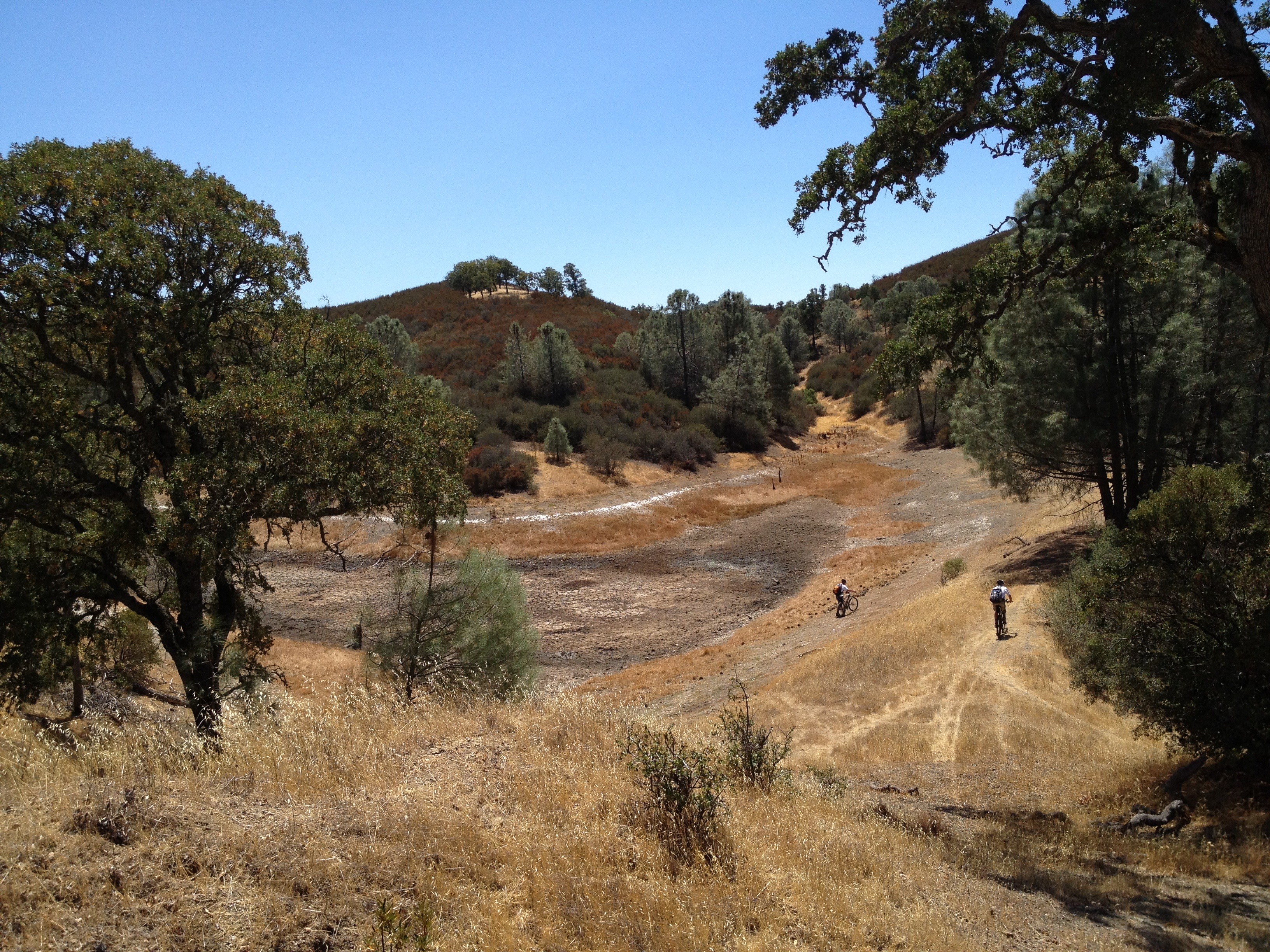
We were dropped off at the southern end of the route at Nevada’s Spooner Lake State Park. http://parks.nv.gov/parks/marlette-hobart-backcountry/ From there, it was a 1200 foot vertical climb, over 4 miles, on a fire road to the beautiful Marlette Lake. From there, the Flume Trail begins!

Approaching Marlette Lake @ 8100 foot elevation

Approaching Marlette Lake @ 8100 foot elevation

IMG_6179

IMG_6172

The Flume Trail actually was a 19th century water flume, taking water from Marlette Lake, high above Lake Tahoe, via a narrow flume.

IMG_6181

It was carved out of the edge of the mountain overlooking Lake Tahoe. It’s not a place for those afraid of heights or any balance issues. The trail is quite narrow in spots, and you would tumble VERY far if you left the trail.

IMG_6193

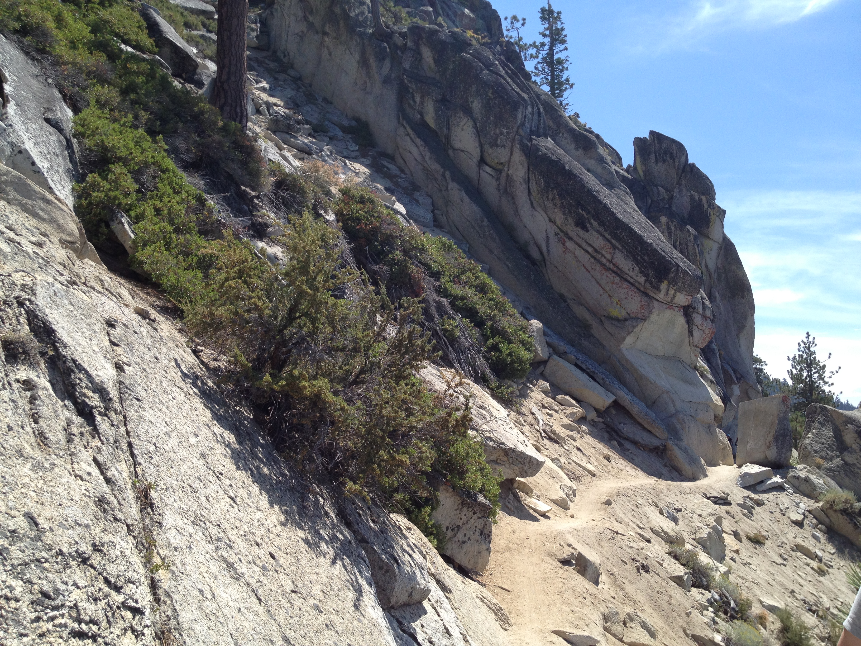
Yes, that’s the narrow trail on the right side of the above photo!

After awhile we found ourselves at the most scenic spot, looking down upon Tahoe’s most scenic beach, Sand Point. http://parks.nv.gov/parks/sand-harbor/

IMG_6188

At the end of the historical (and relatively flat) Flume Trail, we turned downhill and descended over 1000 feet, back to the shuttle starting point, where our car was and had lunch at the adjacent Tunnel Creek Cafe http://tunnelcreekcafe.com/

Awesome trip! Highly recommended as the best spot for a mountain bike ride on your first visit.

More photos: http://www.flickr.com/photos/59666465@N00/sets/72157635143831850/

GPS track (Flume Trail): http://www.everytrail.com/view_trip.php?trip_id=2274258

Posted in Uncategorized | Leave a comment

Cycling Lake Tahoe (day 1)

Day 1 of a delayed report from mid-August!

A good friend and I planned a mountain biking trip to Lake Tahoe several months in advance. We put this mid-August weekend on our “family calendars” several months in advance. We didn’t look at lodging until about 6 weeks before and, “ugh!”, it was expensive! $199 a night for the cheapest lodging in the Truckee / Tahoe City / King’s Beach area. A quick “texting session” and we agreed that Car Camping would be a good idea, as long as they had post-cycling showers!

We got REALLY lucky and found only one site available, even looking as far away as Donner Lake. It was right in Tahoe City! A short walk to restaurants, and a 2 minute walk to a coffee and bagel shop. Though earplugs were necessary and our site had all the charm of a parking lot, it worked out very well. It was an excellent location, where we could watch the bicycles at night, as well as leaving our cooking gear at home and walk to restaurants and Safeway. I think we hit upon a recently cancelled reservation at just the right time… http://www.parks.ca.gov/?page_id=504

We left Silicon Valley on a friday around 2:30. We hit a few traffic bottlenecks on the way. We managed to get to our destination, and set up our tents, just as it was getting dark.

The next morning, we headed out of camp, on our bicycles, to the nearby Tahoe Rim Trail. (did I mention this was a convenient location?) We found the trailhead in a residential neighborhood close by and started our climb.

IMG_6144

Soon we were looking down on the Truckee River Valley and the Highway 89 corridor, headed northeast from Tahoe City. (Yes, those are rafts on the river!)

IMG_6150

Shortly thereafter we went from rocky singletrack to the “Fiberboard Highway”. This “highway” is a former logging road, which goes from the forest above Tahoe City to the Brockway Summit on Highway 267, about 8 miles ot the northeast. A few miles into the Fiberboard Highway, we got some advice from a passing cyclist, who recommended a much more interesting single track back down to the shore. A beautiful loop ride, which brought us back very close to our campsite in time for a quick swim at the public beach before sunset.

IMG_6155

We were now looking forward to the next day’s ride on the famous “Flume Trail”, high along the eastern shore of Lake Tahoe. It has the BEST views in the area.

Yes, and it was smoky over the lake in the evenings due to a fire near Foresthill, CA. The daytime views were unobstructed, however! The winds kept the smoke away from the lake earlier in the day.

IMG_6157

More photos: http://www.flickr.com/photos/59666465@N00/sets/72157635143831850/

Posted in Uncategorized | Leave a comment

Up from the Ground Came a Bubblin’ Crude! (“Tarwater Creek” in Pescadero Creek County Park)

You may be familiar with the Beverly Hillbillies if you watched 1960’s Black and White TV reruns (…or was it just that my parents TV was B&W when I was a kid?) http://www.youtube.com/watch?v=NwzaxUF0k18

…but did you know that there’s natural crude oil in San Mateo County, very close to San Francisco?

IMG_6376

Indeed, there is a natural oil occurrence in the appropriately named “Tarwater Creek” in Pescadero Creek County Park. Quotation from the park’s website:

http://www.co.sanmateo.ca.us/portal/site/parks/menuitem.f13bead76123ee4482439054d17332a0/?vgnextoid=067bc8909231e110VgnVCM1000001d37230aRCRD&cpsextcurrchannel=1

“Pescadero Creek Park sits atop a deposit of natural gas and oil. Natural gas occasionally bubbles up through seams near Hoffman Creek producing a strong gas odor. Crude oil pools up in the channel of Tarwater Creek, and seeps into Jones Gulch Creek staining the rocks. Oil exploration was attempted in the 1970’s but failed to hit the pool. Natural gas under San Mateo County has been estimated at 10 billion cubic feet but no exploration wells have been attempted in the park.”

There was also some limited historical oil production in the 1880’s on the coast to the west http://www.pescaderomemories.com/?p=892

The primary spot on Tarwater creek consists of a pool of tar, within some old river rocks. Poking a stick in it, it seems to be a few inches deep and about 2 foot diameter. This thick tar slooowwwly makes it’s way down the creek, which is flowing quite slowly this time of year. We maybe saw 2 or 3 gallons in all, with a very distinctive smell on an ~85F degree day.

IMG_6374

IMG_6373

So…our goal for the day was to visit this oil seep for the second time (and my friend’s first time). We parked at the obscure trailhead on Camp Pomponio Road, off Alpine Road and started an ~11 mile clockwise loop. If you notice the GPS track, linked below on Everytrail, you’ll see that the first ~5 miles are not recorded, due to the App crashing on my iPhone.)

We saw some of the remaining old growth redwoods. Like some of the other areas of redwood habitat, an occasional single redwood tree was left behind because it was oddly shaped, or otherwise damaged by fire or lightning and did not make good lumber. This one was oddly shaped way up high.

IMG_6361

IMG_6360

The loop was largely uneventful, but a nice shady hike, on an otherwise warm day. We saw nobody else on this beautiful weekday hike, except for 3 small groups of equestrians. Judging from the “steaming piles” along the trail, there’s quite a bit of equestrian usage around here.

Towards the end of our hike, we stumbled upon the abandoned Beverly Hillbillies home, used prior to their move to the 90210 zip code!

IMG_6380

IMG_6388

The main park description is here: https://parks.smcgov.org/pescadero-creek-park

Here’s the trail map. We came down from the upper-right corner, via Alpine Road, from Skyline Blvd. Parking was at the “Tarwater Trailhead”: https://parks.smcgov.org/sites/parks.smcgov.org/files/Pescadero-SamMcDonald-Memorial-Complex-Map.pdf

That’s it! Have fun!

GPS track: http://www.everytrail.com/view_trip.php?trip_id=2294301

More photos: https://www.flickr.com/photos/59666465@N00/sets/72157635310604953/

Posted in Uncategorized | 2 Comments

San Bruno Mtn, near San Francisco: Urban #MicroAdventure

IMG_6277

Not quite as exciting as my longer adventures, especially because we were walking inside of a cloud for 3 hours!

I’m a “Junior” member of a local hiking group, composed of retired guys from the Palo Alto and Los Altos area. Their median age is about 25 years older than mine, and they’re quite a wonderful and inspirational group. They hike every friday, followed by a very leisurely lunch. I join them a few times a year.

IMG_6298

Yesterday we hiked on San Bruno Mountain, which is between the city of San Francisco and the SFO airport. You may be familiar with it if you’ve seen the hillside letters: “South San Francisco The Industrial City”. The top of San Bruno is accessible by car, for a small fee. We parked at the bottom and hiked to the top. On a clear day the views of SFO, the City of San Francisco, and the SF Bay are amazing. Not so much yesterday!

IMG_6295

GPS Track (~7 miles): http://www.everytrail.com/view_trip.php?trip_id=2282399

More photos: http://www.flickr.com/photos/59666465@N00/sets/72157635211451999/

Posted in Uncategorized | Leave a comment

Kelly, Coit and Hoover Lakes @ Henry Coe State Park

Yesterday I enjoyed a huge 11 hour day in Henry Coe State Park!

Grizzly Gulch ~7:00AM
I started Geocaching in late 2005 and credit it for expanding my horizons of the immense network of trails and parks in and around Silicon Valley. There are a small handful of geocachers who do “significant” day trips in the immense Henry Coe SP. It happens that one of them planted a new 32 cache series, and yesterday I went with 2 of the other “extreme Coe” cachers and spent 11 hours slogging up and down hills. (I don’t actually locate as many actual caches as I used to, but I still use it frequently as a research tool and for new ideas. It’s a great way to discover new places and “local knowledge” of places you haven’t been yet.)

We met at the Hunting Hollow trailhead at 6:15AM, leaving one car there, and taking the other up to the Coyote Creek trailhead and were on our way at 6:30AM. We did the long uphill climb to Kelly Lake, arriving at 9:00AM

Kelly Lake at 9:00AM
From there, we started following the little arrow on our GPS and collected the 31 clues to the “final” cache puzzle.
IMG_6246
It took us on some trails none of us had been on before, including the White Tank Spring Trail, on the way to the (very dry) Hoover Lake, which was the furthest point from the cars.

IMG_6255
From there, we circled back a second time to Kelly Lake, this time to include filtering some “Frog Water” ™ to drink. I had already consumed 3.5 liters and had planned to filter more. We finally achieved our goal of the day, and headed back to the cars after 11 hours. Whew!

We saw nobody else the whole day. No other cars at the entrances either, except for one at Coyote Creek when we returned. The temperature was in the high 80’s and the park was very dry.

FINAL TALLY:
Geocache challenge: check!
One “field repair” of a mountain bike: check!
“Road rash” from a downhill bicycle tumble (not me!): check!

Many thanks to my 2 colleagues, including the “chief navigator and disc brake mechanic”, who ensured our safe return, as well as to “the master of Coe caches and near-death adventures”!

GPS track at EveryTrail (minus the last few miles back to the starting point, as I had run out of “juice”: http://www.everytrail.com/view_trip.php?trip_id=2279873

More photos: http://www.flickr.com/photos/59666465@N00/sets/72157635184134471/

Posted in Uncategorized | 2 Comments

Uvas County Park, Maymen’s Flat, Kim Son Monastery

The Kim Son Buddha

A mini-adventure, including looking for a hidden gravesite, this morning near Silicon Valley! A toasty day, with a temperature of 93F at one point. (One of these days I’ll try Columbia’s wicking shirts. For now I use my old collection of 4 lightweight long-sleeve running shirts with great SPF ratings.)

I parked my car at the not-so-well-known upper end of Uvas County Park. http://www.sccgov.org/sites/parks/Maps%20Here/Pages/Uvas-Canyon-County-Park.aspx This little known entrance is accessed via Summit Road to Mt Bache Road. It includes several miles of dirt roads, which are properly graded for normal clearance 2WD cars, though I would be concerned of the roads were wet.

I strolled DOWN to the prominent Knibbs Knob, which is a significant hike from the main entrance of the park. Between where I parked and the turnoff to Knibbs Knob, I was looking for an outcropping, which according to my reliable source, contains the funeral urn of a family member that used to own this land! My source told me that when the land was transferred, the family stipulated that the urn would remain where it is in the upper reaches of the property. My source is reliable, but the location was lacking in details…I poked around a bit and failed. I did see one spot that warrants a further look, but it was in some deep, scratchy tick-and-poison-oak brush. Another time, perhaps!

IMG_6112

After that short stroll, I decided to continue south on Summit Road, past the old and rusted sign that says “Private Road, No Trespassing”. I had been to this spot and turned-around several times before. I also talked to a few friends that had one through there, as well as done some research.

It seems that this “shortcut” down towards Mt Madonna County Park and Watsonville was not properly maintained by Santa Cruz County and the local residents formed the “Summit Road Association” to take matters into their own hands. They spent their own time and money repairing the road and erected gates. There was some back-and-forth legal wrangling, with the county still saying it’s a county road. Recently the gates have not been used, particularly after the big fire about 4 years ago. The sign about “no bicycles” is much newer and prominent. There are also several properties for sale back there. So…I ventured through the 6 mile stretch of road, waving at the 2 cars that I passed, with the goal of looking at some of the properties that are for sale, in case anybody asks… (Note: I would not do it on a bicycle, and I’m not responsible if you go and one of the locals gives you a hard time! If you know more about this stretch of road, I can add to, or modify my information.)

After 6 miles, and passing through the southern gate, the pavement begins again and I soon got to the Kim Son Monastery, http://www.kimson.org/ which graciously allows visitors. I took a few pictures and headed back the way I came. http://www.yelp.com/biz/tu-vien-kim-son-monastery-watsonville

I stopped in the Summit Store for 2 Arizona Iced Teas and a small piece of tasty, crumbly, 7-year-old Quebec extra sharp cheddar http://www.summitgrocerystore.com/ I was back home after about 5 hours and a little mini-adventure!

GPX track of the hike: http://www.everytrail.com/view_trip.php?trip_id=2265325

More photos: http://www.flickr.com/photos/59666465@N00/sets/72157635059650923/

The Lion Stops at the Entrance

The Lion Stops at the Entrance

Posted in Uncategorized | Leave a comment

Bushwhacking Aptos Creek, Nisene Marks S.P., Santa Cruz, CA

IMG_6068

IMG_6075
IMG_6091

The Forest of Nisene Marks State Park, near Santa Cruz CA, has miles of established trails in lush second growth redwood forest. http://en.wikipedia.org/wiki/The_Forest_of_Nisene_Marks_State_Park …however, with all the established single track trails and double track “fire roads”, there are many acres and areas that are quite difficult to access and rarely seen. This includes the upper reaches of Aptos Creek.

There are 4 local Geocachers (http://www.geocaching.com) who, starting about 4 years ago, entered these areas and placed some geocaches (“navigation beacons”), as well as documented their adventures with write-ups, photos, and historical research. Despite this flurry of activity, some of these spots have gone unvisited since the initial visit 4 years ago. This past saturday I joined one of these modern explorers and a small group to go up Aptos Creek. (…though by no means were they the first humans there! The creek area includes the ruins of at least one lumber camp and several railroad trestles, used for a short period when the area was being clear-cut of the first growth redwoods. Other than the occasional railroad tie or piece of steel rail in the creek, you would never know!)
IMG_6055

Wow…prior to the trip we estimated 6 to 10 hours to go upstream, then back via the trail. It actually was just short of 14 hours, including scaling miles of rocks, waterfalls, and downed redwoods and seeing some beautiful scenery, including “5 Finger Falls” and hordes of ladybugs. We did not “just” go to “5 Finger Falls”, also called “Aptos Creek Falls”. We ventured further than any other (non-Geoaching) write-ups I could find on the internet. We stayed in the increasingly narrow and more difficult creekbed for several steep miles beyond that, up to the “source” of Aptos Creek near where the first trickle of water starts seeping out of the hillside way up above the coastline of Santa Cruz County. It was slow going, at an average pace of 1 mph for 9 hours. Picking our way through water, rocks, and logjams often required backing up and retracing our steps a bit to find a better path.
IMG_6081
We stumbled back to the car, via flashlight, at 9:45PM. We were happy to not receive any “legal love letters” tucked under our car’s windshield wipers for being in the park way too late.

Now, as the sore muscles recover, and the blisters and scratches heal, my memory becomes sealed: WHAT A GREAT TRIP it was! It was an awesome adventure, which I would do again…but maybe not right away and maybe with an earlier start!

IMG_6062

IMG_6088

IMG_6094

More photos: http://www.flickr.com/photos/59666465@N00/sets/72157635021945391/

The track up the creekbed: http://www.everytrail.com/view_trip.php?trip_id=2261492

Posted in Uncategorized | Leave a comment

Castorland: French Refugees in the Western Adirondacks, 1793-1814

gallucci

Most folks who live in the Adirondacks Mountains of New York don’t even know some of the unusual events in local history. I Just plowed through a book that’s been on my shelf for awhile “Castorland: French Refugees in the Western Adirondacks, 1793-1814” by Edith Pilcher Link: http://amzn.com/0916346552

Back in 1793 the “Compagnie de New York” was founded in Paris and stock shares were sold to a virgin 200,000 acre tract to be developed and settled in northwestern NY State. The shares sold quickly to investors and French nobility, both as land speculation, and a place to flee the violence of the French Revolution by nobility and “monarchists”.

The story centers around the failed colony, which never achieved more than 20 families. It started with an inaccurate map making them think they bordered on Lake Ontario for easy access and trade with Canada, when it was 2 days travel without a navigable river to get there. The advertising literature, created in Paris, took the best aspects of NY State and assigned those same characteristics to this remote tract, with the harshest weather in the region (-40F in winter). It was the same latitude as balmy southern France!

Though the French nobles, fleeing the guilloutine, settled in many places in the New World, most of them were not used to hardship or the hard work which had formerly been done by their servants in France. A few adapted, including Simon Desjardin, who led the fledgling settlement. His hardships and pace of progress was quite slow, and he was eventually replaced by a Swiss investor who “managed” the colony from the comfort of New York City. The unplanned hardships, mismanagement, plus Napoleon Bonaparte welcoming nobility back to France in 1802, sealed the colony’s fate. Many French settlers continued arriving in North America, but they were predominantly peasants and/or settled inurban areas.

Desjardin’s journal, combined with other historical entries, also interestingly shows cultural clashes with the French nobles. They were used to much more gracious hospitality and gentlemanly business dealings than the Americans offered. Their commentary was quite a contrast to the more famous and enthusiastic writings, a few decades later, of Alexis de Tocqueville http://en.wikipedia.org/wiki/Alexis_de_Tocqueville

The author does a great summary reviewing and correcting historical literature, which primarily is Simon Desjardin’s journal, which was found at a flea market in Paris by an American in 1862. It’s now translated and available: “Castorland Journal: An Account of the Exploration and Settlement of New York State by French Émigrés in the Years 1793 to 1797” by Simon Desjardins Link: http://amzn.com/0801446260

If you like early frontier or Adirondack history, I recommend it.

Posted in Uncategorized | Leave a comment

If you run me over in a cemetery, please dig a hole first. (Up and over El Sereno Open Space, Saratoga and Los Gatos)

IMG_5992

IMG_5998

Well, this weekday local adventure started out with a big, bad adrenaline rush. I parked my car near the historic Madronia Cemetery in Saratoga, CA (http://www.madroniacemetery.com/) to start my cycling trip. It was a quiet thursday morning, and I stopped about 20 feet from the only other visitor to read one of the older headstones. I on my bike, and the visitor in her vehicle. As I contemplated eternity under the well kept grass of this serene spot, I looked over my shoulder to see the white reverse lights of an Acura MDX about 2 feet from my face! I shouted “hey hey hey” and she stopped just as I started banging on her rear window and hopping off my stationary bicycle. I was shocked…she said “I couldn’t see you”. PLEASE…if you can’t see behind you, buy a smaller vehicle or take the bus next time. Lastly, if you’re gonna run over someone in a cemetery, it would be courteous to dig a 6 foot hole first.

From there, I slogged up the steep Bohlman Road on my bike, according to plan, to the northwest entrance to El Sereno Open Space Preserve http://www.openspace.org/preserves/pr_el_sereno.asp

I found, for my second time here, the park entrance, which is open to the public, but poorly marked. It looks like a private gravel driveway. I then stopped at the “El Sereno” benchmarks, took a few photos of Lexington Reservoir and San Jose. From there, I zig-zagged down the Aquinas Trail to Sheldon Road and Highway 9 in Los Gatos. I followed the busy Highway 9 back to Saratoga and a stop at the cute little http://www.bigbasincafe.com for a muffin and 2 Arizona ice tea.

Pictures: http://www.flickr.com/photos/59666465@N00/sets/72157634897880389/

Track: http://www.everytrail.com/view_trip.php?trip_id=2245343

Posted in Uncategorized | Leave a comment

Chemeketa Park & Redwood Estates

9.4 miles and (an exaggerated) ~3000 feet of climbing around these two interesting residential areas…including Holy City and Ryland Dam at the headwaters of Los Gatos Creek.

http://www.everytrail.com/view_trip.php?trip_id=2225141

More photos: http://www.flickr.com/photos/59666465@N00/sets/72157634754394086/

Ryland Dam on Los Gatos Creek

IMG_5815

Historical marker in front of Mountain Charlie’s cabin in “Patchen”

Image

Posted in Uncategorized | Leave a comment