A few weeks back, I met-up with a friend for two nights in Death Valley. We “boondock” camped off the beaten path, though we centered most of our activities near Panamint Springs, where initially met-up, then had breakfast both days (and maybe a flush toilet!).
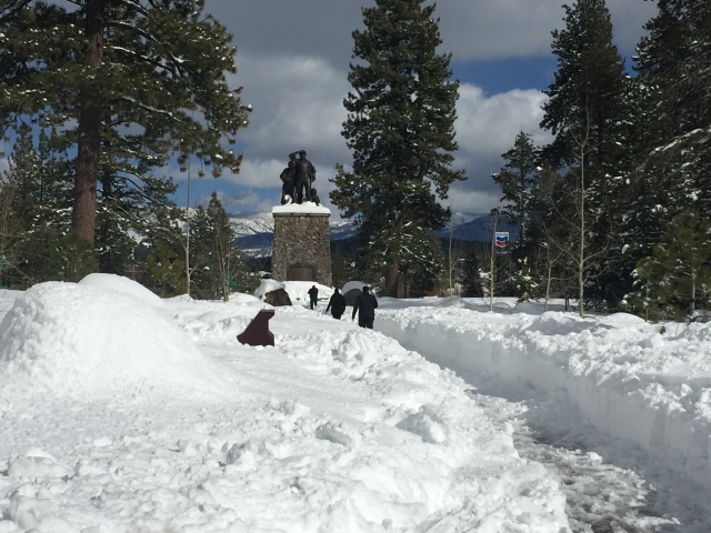
First, I headed to Lake Tahoe for a day of skiing. (Below is Donner State Park, where, you know, those folks were stranded in a winter storm in the 1800’s and did what they had to do, in order to survive.)

The plaque on the rear of the Pioneer Statue reads (from Wikipedia):
NEAR THIS SPOT STOOD THE BREEN CABIN OF THE PARTY OF EMIGRANTS WHO STARTED FOR CALIFORNIA FROM SPRINGFIELD, ILLINOIS, IN APRIL 1846, UNDER THE LEADERSHIP OF CAPTAIN GEORGE DONNER. DELAYS OCCURRED AND WHEN THE PARTY REACHED THIS LOCALITY, ON OCTOBER 29, THE TRUCKEE PASS EMIGRANT ROAD WAS CONCEALED BY SNOW. THE HEIGHT OF THE SHAFT OF THE MONUMENT INDICATES THE DEPTH OF THE SNOW, WHICH WAS TWENTY-TWO FEET. AFTER FUTILE EFFORTS TO CROSS THE SUMMIT THE PARTY WAS COMPELLED TO ENCAMP FOR THE WINTER. THE GRAVES CABIN WAS SITUATED ABOUT THREE-QUARTERS OF A MILE TO THE EASTWARD, THE MURPHY CABIN ABOUT TWO HUNDRED YARDS SOUTHWEST OF THE MONUMENT, AND THE DONNER TENTS WERE AT THE HEAD OF ALDER CREEK. NINETY PEOPLE WERE IN THE PARTY AND FORTY-TWO PERISHED, MOST OF THEM FROM STARVATION AND EXPOSURE.
IN COMMEMORATION OF THE PIONEERS WHO CROSSED THE PLAINS TO SETTLE IN CALIFORNIA. MONUMENT ERECTED UNDER THE AUSPICES OF THE NATIVE SONS AND THE NATIVE DAUGHTERS OF THE GOLDEN WEST. MONUMENT DEDICATED JUNE 6, 1918
The next day, I skiied at Sierra-at-Tahoe. They had several feet of new snow in the prior few days. The conditions and weather were incredible.

The next day, I headed south, along the Eastern Sierra’s Route 395. In the distance, from Conway Summit, is the really funky and salty Mono Lake (“thank you” Los Angeles Water Department.)

…followed by the Closed-for-the-Season “Whoa Nelllie Deli”, at the base of Yosemite’s Tioga Pass entrance:


…and my third or fourth visit to Manzanar. I stopped for a few quick photos, and the restrooms. If you’ve never been, plan about 2 hours, and be sure to see the movie in the Visitor’s Center. https://en.wikipedia.org/wiki/Manzanar

Eventually, fill your tank and hang a left when you get close to Mt Whitney, and on to Panamint Springs. It’s a privately owned store, restaurant, campground, and motel at the edge of Death Valley. http://www.panamintsprings.com/ (Cheapest gasoline for about 50 miles in any direction. $5.00/gallon. Also, the only gas for about 50 miles in any direction.)
View from the restaurant porch:

Below, www.DryFJ.com and I tested the new Subaru on some rocky stuff!

Below are the Wildrose kilns. This is in one of the higher elevation parts of Death Valley. You can see the Pinon Pine trees, which were harvested and turned into charcoal in these kilns, in the 1880’s. The charcoal was then transported to a mine, as a fuel source, in a more barren area, about 25 miles away. The silver-lead mine, and the kilns, were owned by the father of William Randolph Hearst. (The kilns were restored in the 1970’s by Navajo stonemasons from Arizona.) https://www.atlasobscura.com/places/wildrose-charcoal-kilns


Bits of snow, near the kilns. Time to repack the cooler, before heading back to lower elevations!

Heading back thru Panamint Springs, we headed north on Saline Valley Road, towards the Boxcar Cabin, our campsite, and the next day’s hike:

The Boxcar Cabin, below, is on BLM land, just outside the National Park. It was restored, and is maintained, by volunteers. We stopped for a few minutes, to poke around and read the visitor’s register. http://deathvalleyjim.com/buckhorn-boxcar-cabin/


From there, we headed further north, to our next campsite…near a secret petroglyph site, which I won’t be blogging about…
Two other blog posts, for two hikes during this trip:
https://alpharoaming.com/2018/04/08/burns-spring-hike-death-valley/
That’s it! we had a great few days, near Panamint Springs. Panamint Springs can be quite toasty in the summer, but it’s a pleasant place to stop, regardless. The current owner’s are from San Jose!


